

This blog is a Book Blog. The entire blog is about a book titled BIAFRA FEDERATION written by me. The book is comprised of eight chapters including the Prologue and the Epilogue.
THE BOOK IS AVAILABLE FOR PURCHASE, ALONG WITH MY OTHER BOOKS, AT
1. LULU PUBLISHING: lulu.com/spotlight/ccnweze - Paperbacks and ebooks
2. OKADA BOOKS: https://okadabooks.com/user/C.C.Nweze - ebooks only
READ, ENJOY, UNDERSTAND, DECIDE

Biafra
Federation
Celestine
Chukwuma Nweze
Dr C. C.
Nweze
The
True Vine Clinic
184
Agbani Road
Enugu
E-mail:
ccnweze@gmail.com
Website:
Fountain of Reason
(foutainheadrepository.com)
First
Published July 2018
All Rights Reserved
No part of this publication
may be reproduced, stored in a retrieval system or transmitted in any form or
by any means, electronic, mechanical, photographing, recording or otherwise,
without the written permission of the author.
ISBN:
978-1-387-98260-8
ACKNOWLEDGEMENTS
I share a lot of passion on this subject, and on
writing, with one of my best friends, Heck Okpani of Gerizim Ventures. We have
come a long way together and he has inspired me in many ways.
This book, Biafra
Federation, has drawn very significantly from my previous book, Biafra Our Default Homeland, with
materials from multiple paragraphs in the latter being part of some relevant
sections of the former. In each of four special instances, a whole large
section of a chapter in the latter has been lifted and grafted to the relevant
chapter of the former, in a discussion of a similar subject in the same
author’s similar perspective. This is deliberate and very necessary, as can be
seen on reading this book, the discussion and comprehension being easier than
with having to necessarily consult a different book extensively.
Highly impressed and inspired I am, by those ardent
protagonists of True Federalism as the best form of government, especially in
the case of a union of diverse groups such as diverse ethnicities or diverse
nationalities.
DEDICATION
To all citizens of the Biafra Homeland who love to be identified as Biafrans
To all authentic Africans who are proud of their bona fide African heritage
To all apostles
of self-determination, emancipation of peoples and responsible leadership.
PROLOGUE
Chief Frank Opigo, an Ijaw man from Yenagoa, threw
in the suggestion that immediately struck the right cord. It resonated like
they all started saying, “Hey, we should have known that. What were we all
thinking, looking for a name for our country while the name for our country has
been right here looking at us? Of course this is Biafra homeland!”
It was very easy to see that Bight of Biafra
indicated the name of a place which that bay was known as its bight. The
homeland sitting on that Bight of Biafra was, certainly, called Biafra.
The occasion was the meeting called by Col Odumegwu
Ojukwu to discuss the withdrawal of Eastern Region from Nigeria. Suggestions of
the name for the emerging country were considered and Biafra was chosen. It was
accepted by all and the Republic of Biafra was declared on the 30th
day of May 1967.
The rest of Nigeria went to war against little
Biafra, backed by Britain and Soviet Union, among other conniving countries.
Eastern Nigeria was re-integrated into Nigeria in 1970.
Many people do not yet know why “Biafra” was chosen
as the name of the break-away country. Those who chose it knew, however, that a
homeland called Biafra Kingdom included the whole of the Nigeria’s Eastern
Region and began from the East Bank of the River Niger, across which it could
easily extend a warm handshake to its neighbor, the Benin Kingdom, also sitting
on a similar bight, the Bight of Benin. They knew that Biafra Kingdom stretched
eastwards to include the whole of Eastern Nigeria and the area of present day
Cameroon, Gabon and Equatorial Guinea.
There exists, today, a much desired principle of
retracing the natural boundaries of indigenous African nations destroyed and
distorted by balkanization resulting from the scramble for Africa by the
Europeans, following the Berlin Conference of 1884-1885. Europe's arbitrary post-colonial borders
left Africans carved into countries that did not represent their heritage. This
is a contradiction that still troubles Africa and her peoples today. The
names of those primary African nations were also effaced, and they lost their autonomy along with the
effacement, following the balkanization and colonization. After independence
those countries that emerged in the new Africa, post scramble, lost the
identities of their indigenous homelands some of which were great nations; they
now have nothing to show for their previous exalted existence.
Although the Europeans (their governments) were
responsible for the loss of the identities of the original African nations, it
is important and in deserved fairness, to say that those African nations were
identified and documented by Europeans (explorers, travelers and cartographers),
making it possible for us to have known about them.
The
identities were lost into the emerging colonized countries but few of them had
landmarks that pointed to their full identity. One of these is Biafra.
Biafra
was not lost completely and there is still a landmark with which to retrace her
original boundaries completely. This landmark is the Bight of Biafra. Bight of Biafra is the broad bay within the Gulf
of Guinea of the Atlantic Ocean which marks the coastline of Biafra. In other
words, Biafra kingdom was lying on the Bight of Biafra. With this landmark and
the knowledge obtained from the historical maps made by the European
cartographers, the original boundaries of the Biafra homeland can be retrieved.
When that is done, what do we do with it? The great answer lies in the Biafra
Federation.

CONTENTS
Prologue………………………….....5
Before
Destruction………………..10
Destruction……………………......34
Retrieval…………………………..47
Federation of
Champions………..65
Center of the World…………… ..71
Government…………………… ..80
Epilogue……………………….....99
BEFORE DESTRUCTION
There is an indigenous African homeland that can
still be retrieved successfully in line with present discussions in Africa
concerning the desired native borders and the arbitrary European borders that
separated Africans of the same heritage. Biafra is that indigenous African
homeland.
Historical maps exist which show wonderful early precise documentations of the existence of civilizations organized into various named homelands some of which were large and powerful kingdoms. One of the large kingdoms documented by cartographers is Biafra. These maps have been preserved in their original forms in various important locations most of which are prominent libraries mostly in prestigious world universities. These maps have been located in these famous sources and are here arranged chronologically, up to the present.
The sources of these maps on display here are:
1. Princeton University Library, New Jersey USA
2. James Ford Bell Library, University of Minnesota, USA
3. Michigan State University Map Library, USA
4. The Bodleian Libraries, Oxford, United Kingdom
5. The Philatelic Database (www.philatelicdatabase.com/)
6. David Rumsey Map Collection Cartography Associates (www.davidrumsey.com),
7. Stamp World History (http://www.stampworldhistory.com/country-profiles-2/africa/biafra/ ).
8.
Originalpeople.org, http://originalpeople.org/berlin-conference-1884-85/
A zoom-in to West Africa and part of Central Africa is shown alongside each full map of Africa
Historical maps easily show that the homeland called Biafra existed a very long time ago in history and was a major civilization in West Africa, and that it was maintaining that name in maps until late 19th century, after European countries shared up Africa and gave different names to their own share of African lands, overriding the autonomy of those great kingdoms and their age-long identities.
A
number of African nations are already trying, as much as possible, to regain
their lost identities, and recover the names of their cherished bona fide
homelands, by going back to history and identifying their roots and the real
names of their bona fide homelands.
16th Century:
1584 Map 1

1584 map Ortelius, Abraham, “Africae tabula noua.” From Ortelius’s Theatrum orbis terrarum Antwerp, 1584, [Historic Maps Collection: https://libweb5.princeton.edu/visual_materials/maps/websites/africa/maps-continent/1584ortelius.jpg

SOURCE: Princeton University Library
This
standard map of Africa for the last quarter of the sixteenth century is from
Abraham Ortelius (1527-1598) who lived and died in Antwerp in Northern Belgium,
where he had a bookselling business.
The
Portuguese pronounced Biafra as Biafar and that is what is written in those
very early maps like this one. Some other Europeans called it Biafara and
Biafares perhaps depending on the Europeans’ language and nationality. It was
corrected to Biafra before long and it is still Biafra till date.
Obviously
a map drawn in 1584 cannot be accurate according to the modern standards of
cartography. But it can be said to be accurate according to the standards of
the time as the cartographers used information obtained from European travelers
and explorers to make their maps. They did an incredibly good job, given the
facilities available to them, in comparison with the technology of now. This is
because, inaccurate as they obviously are in comparison with today’s maps, they
wonderfully correlate with, and can easily be accurately extrapolated to
confirm present realities. Naturally, the maps kept getting better over the
years.
17th
Century:
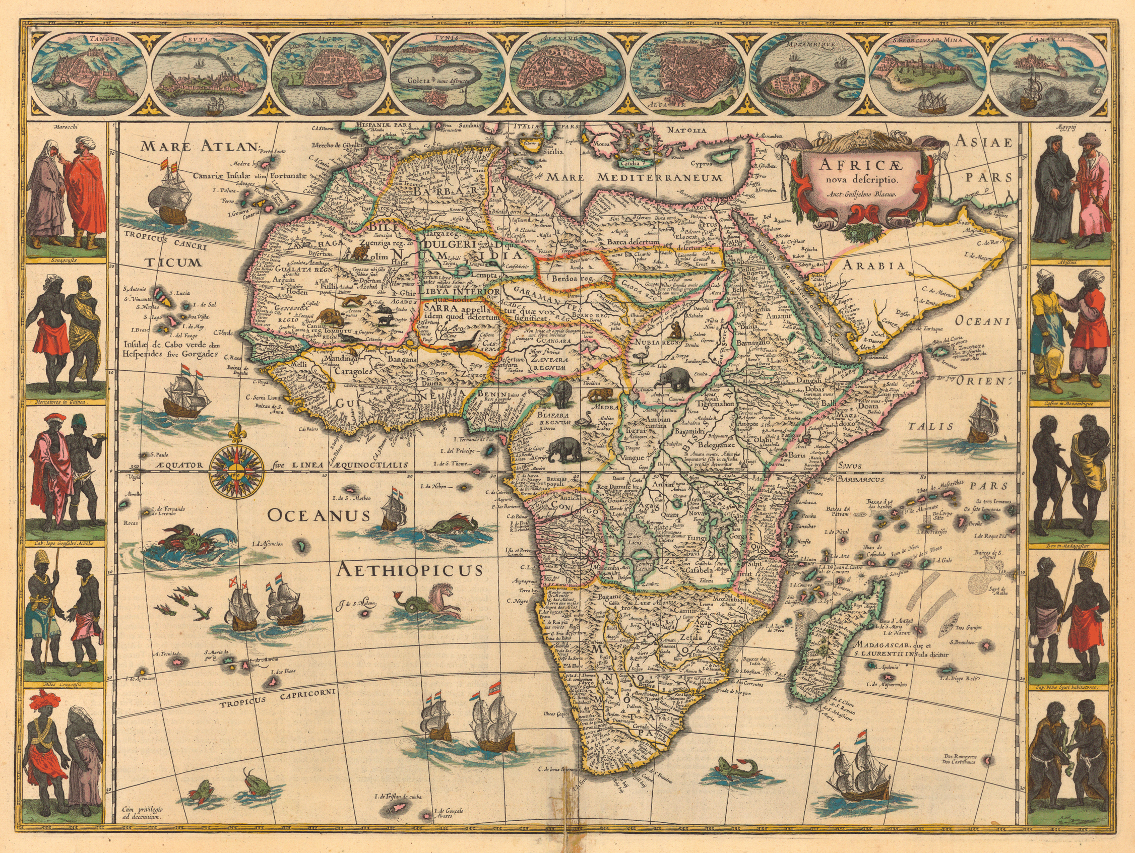
1644 Map 2

1644 map Blaeu, Willem Janszoon, 1571-1638. “Africae nova descriptio.” (Amsterdam, 1644). Gift of J. Monroe Thorington https://libweb5.princeton.edu/visual_materials/maps/websites/africa/maps-continent/1644%20blaeu.jpg

SOURCE: Princeton University Library
Described
as “one of the most decorative and popular of all early maps of Africa, from
the ‘golden age’ of Dutch mapmaking” by the Princeton University Library, this
beautiful map of Africa with fine engraving and coloring was produced by Blaeu,
Willem Janszoon (1571-1638) and shows the kingdom that occupied the space now
known as Eastern Nigeria, Cameroon, Equatorial Guinea and Gabon. Here Biafra is
written as Biafara by the Dutch cartographer (note that all the depicted ships
were assigned Dutch flags). “Side panels depict costumed natives from areas
visited along the coasts. The interior is decorated with exotic animals (lions,
elephants, ostriches), which were (and still are) a major source of fascination
for the public” comments the Princeton University Library. This shows the
travelers and explorers observed a good level of civilization in these areas,
which include Biafra
This 1644 map best shows the borders and the geographical relationships of the various empires. Biafra Empire was bordered in the west by Benin Empire, in the North-West by Zanfara Empire, in the North by Nubia Empire, in the South by Congo and in the East by a group of small nations in Central Africa. The map of Biafra may have taken other shapes down the ages but these defining relationships are to be noted.
1686 Map 3 
1686 Map: 17th Century,
Western and Central Africa Dapper, Olfert, 1639-1689. Description de l'Afrique,
contenant les noms…, leur A Amsterdam : http://umedia.lib.umn.edu/node/1297910
SOURCE: University of Minnesota Library
This
is a watershed map physically located at the University
of Minnesota Libraries, James Ford Bell Library. https://www.lib.umn.edu/bell, produced in 1686 and seems to have become known in 1707.
Largely maintaining the hitherto landmarks and relationships, it reveals Biafra
city as a city that is most probably the capital of, or the most important city
in Biafara Regnum (Biafara Kingdom) which still covers the whole of what is now
the Eastern part of Nigeria starting from the east bank of the river that would
be subsequently identified as the River Niger and be discovered to be
continuous with the big northern, west-east directed river to form the whole
extent of the River Niger. Biafara
Kingdom covers the present Cameroun and further extends down to the area of
present day Gabon and Equatorial
Guinea. The map was either made by, or
from the descriptions of, Olfert Dapper (1636 – 1689 a
Dutch writer); it is credited to him.
18th
Century:
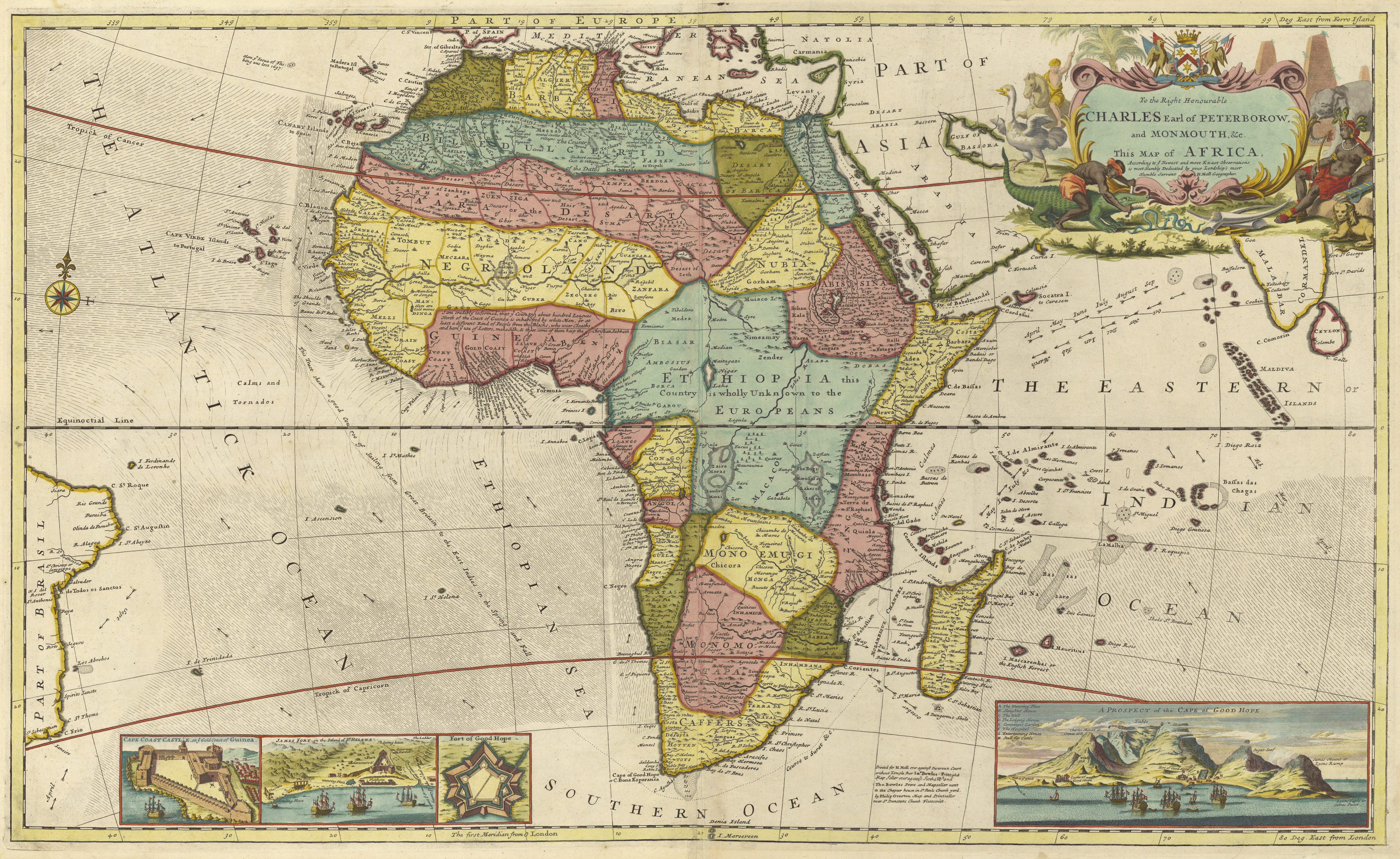
1710 Map 4

1710 map Moll, Herman, d. 1732. “To the Right Honourable Charles, Earl of Peterborow and Monmouth, &c.” [Historic Maps Collection]: https://libweb5.princeton.edu/visual_materials/maps/websites/africa/maps-continent/1710%20moll.jpg

SOURCE: Princeton University Library
A
colorful map made by Herman Moll (1654-1732) a German who lived most of his
life in London where he established a book and map store. He made his maps by
studying the works of other cartographers. It is not easy to say whether that
is why his map of Africa seems less accurate than others although the
relationships are still fairly retained. All the other maps before his were
consistent. Instead of “Biafar” he calls Biafra “Biasar” and he recognizes
Biafar city at the eastern bank of River Cameroons.
1737
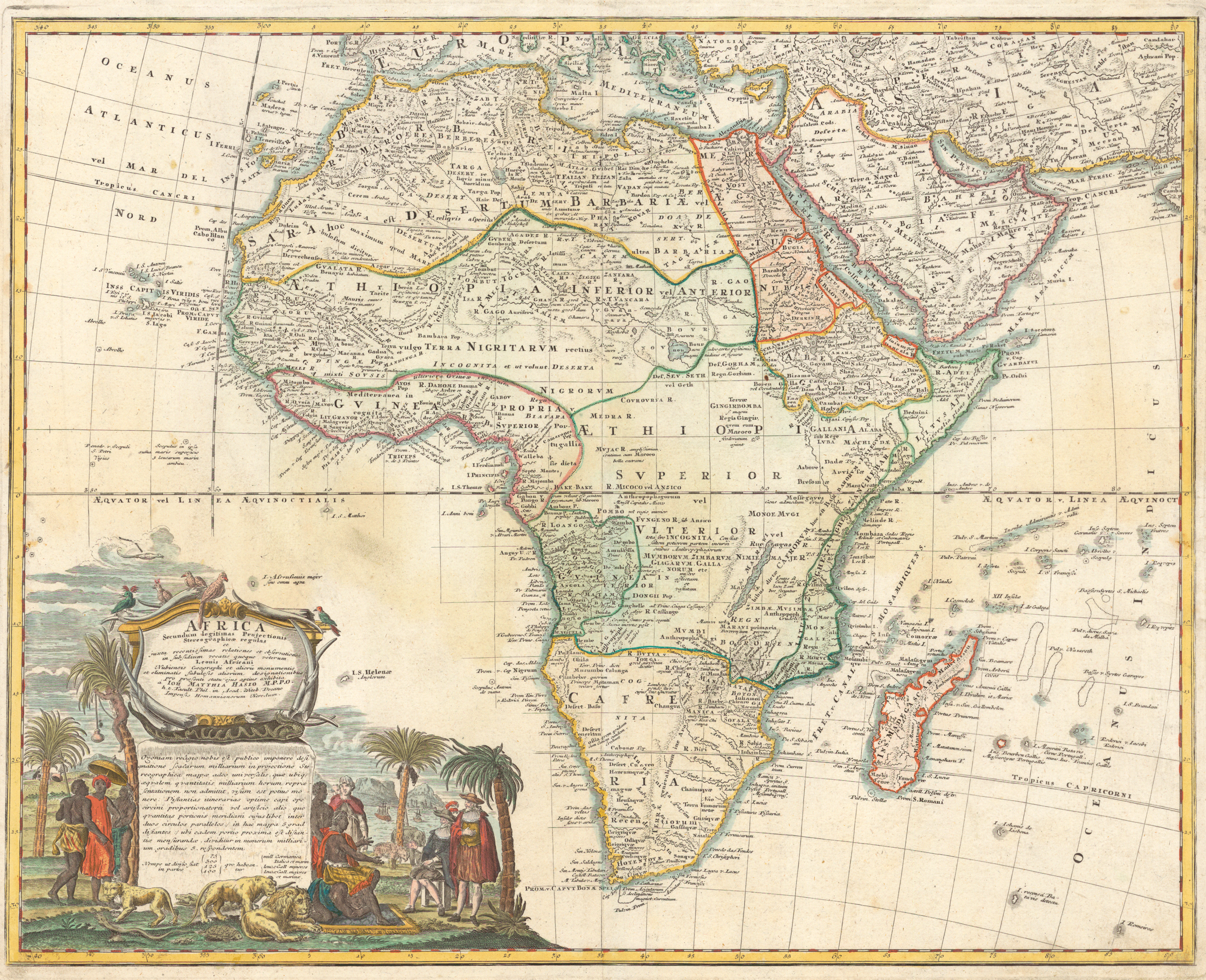
Map 5

1737 map Hase, Johann Matthias, “Africa secundum legitimas . . .” https://libweb5.princeton.edu/visual_materials/maps/websites/africa/maps-continent/1737%20hase.jpg

SOURCE: Princeton University Library
This is a map from Johann Matthias Hase (1684-1742) a German mathematician, astronomer and cartographer. Hase identified important kingdoms and territories in colour and dotted lines and Biafara is one of them. Biafra was a very great kingdom with significant civilization.
For the rest of the century the map did not change significantly. Biafara remained the name used for Biafra and it continued to be shown as a major territory in Africa extending from West Africa to the western part of Central Africa.
Zanfara Kingdom had sappeared from the map and Benin Kingdom was dwindling in prominence. Zanfara kingdom had just been conquered by the Gobir kingdom, under King Babari, which had established its capital at Alkalawa, their Gobir kingdom reaching its height under the reign of King Bawa Jan Gwarzo (1771-1789) in the late 18th century and ending in early 19th century when it was conquered in the Fulani War (Fulani Jihad, of Usman dan Fodio) of 1804–1808, which resulted in the creation of the Sokoto Caliphate headed by Usman dan Fodio himself.
It has to be noted how very restless the northern areas of Sub-Saharan Africa were before 19th Century: multiple wars and conquests, aggressions with military expeditions, and territory grabs in diverse directions. For instance, Zanfara Kingdom sacked Kebbi Kingdom and took control of it, moved against Katsina, another Hausa Kingdom, and took it over and was itself conquered by Gobir kingdom as already noted, and Gobir itself was conquered by the Fulani who also killed Yunka the king of Gobir.
In
sharp contrast, the nations in the Biafra kingdom were, relatively, very
peaceful and industrious people preoccupied with local and international trade,
and development. They intelligently interacted with foreign travelers and
explorers and cooperated with them to advance trade and industry, and promote
education. They put their coastal location to appreciable benefit.
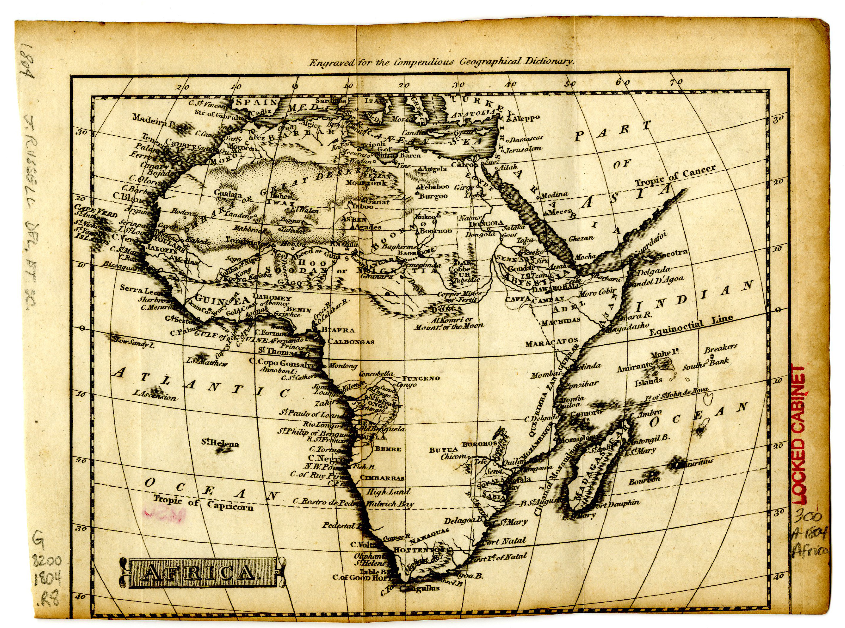
1804 Map 6

1804, Map. Africa. Compendious Geographical Dictionary. Michigan State University Library. http://archive.lib.msu.edu/maps/MSU-Scanned/Africa/300-A-1804Compendious.jpg

SOURCE: Michigan State University Map Library
19th
Century:
By early 19th century Biafara was already being properly called Biafra perhaps due to a better understanding by the foreigners who happened to be the writers and producers of the maps. Biafra has remained the name of that homeland till today. Bight of Biafra had also appeared in the map and has remained till date except in maps produced by those who respect the unfortunate local Nigerian decree of 1975 renaming it to Bight of Bonny.
Unfortunate
was this renaming because of the aim of it that was to delete Biafra from the
map and, therefore, from the consciousness of Nigerians, following the civil
war that occurred, 1967 to 1970, as a result of the declaration of the
secessionist state of Biafra; the aim of it was to remove the memory of the war
from mainstream consciousness of Nigerians. This is a mistake because thus removing the war from Nigerian consciousness
prevents future Nigerians from also having the awareness of the horrors of the
war, the causes and the consequences, thereby condemning them to the
possibility of repeating the very mistakes that led to the war, or similar
mistakes.
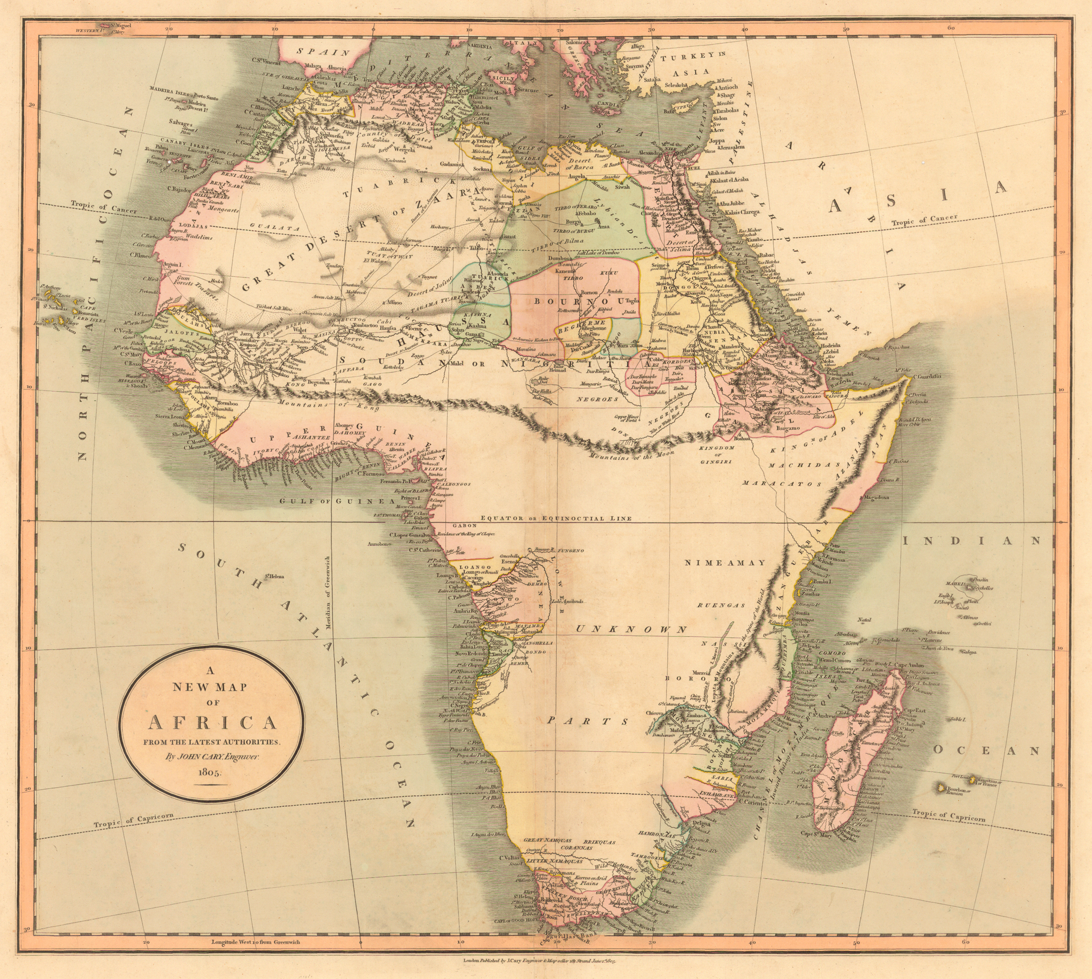
1805 Map 7

1805 map Cary, John, ca. 1754-1835. “A New Map of Africa from the Latest Authorities.” From Cary’s New Universal Atlas (London, 1808). https://libweb5.princeton.edu/visual_materials/maps/websites/africa/maps-continent/1805%20cary.jpg

SOURCE: Princeton University Library
For
the rest of the 19th Century, observe the evolution of these
historical maps and be educated on the striking developments in Biafra over the
years, until the years following the Berlin conference when identities and the
autonomy of nations were removed by the colonizers. Thereafter, identities of the kingdoms of Biafra and Benin continue to
be preserved by the significance of the names of the two bights on which they
are sitting. These are Bight of Benin and Bight of Biafra, also containing
islands therein.
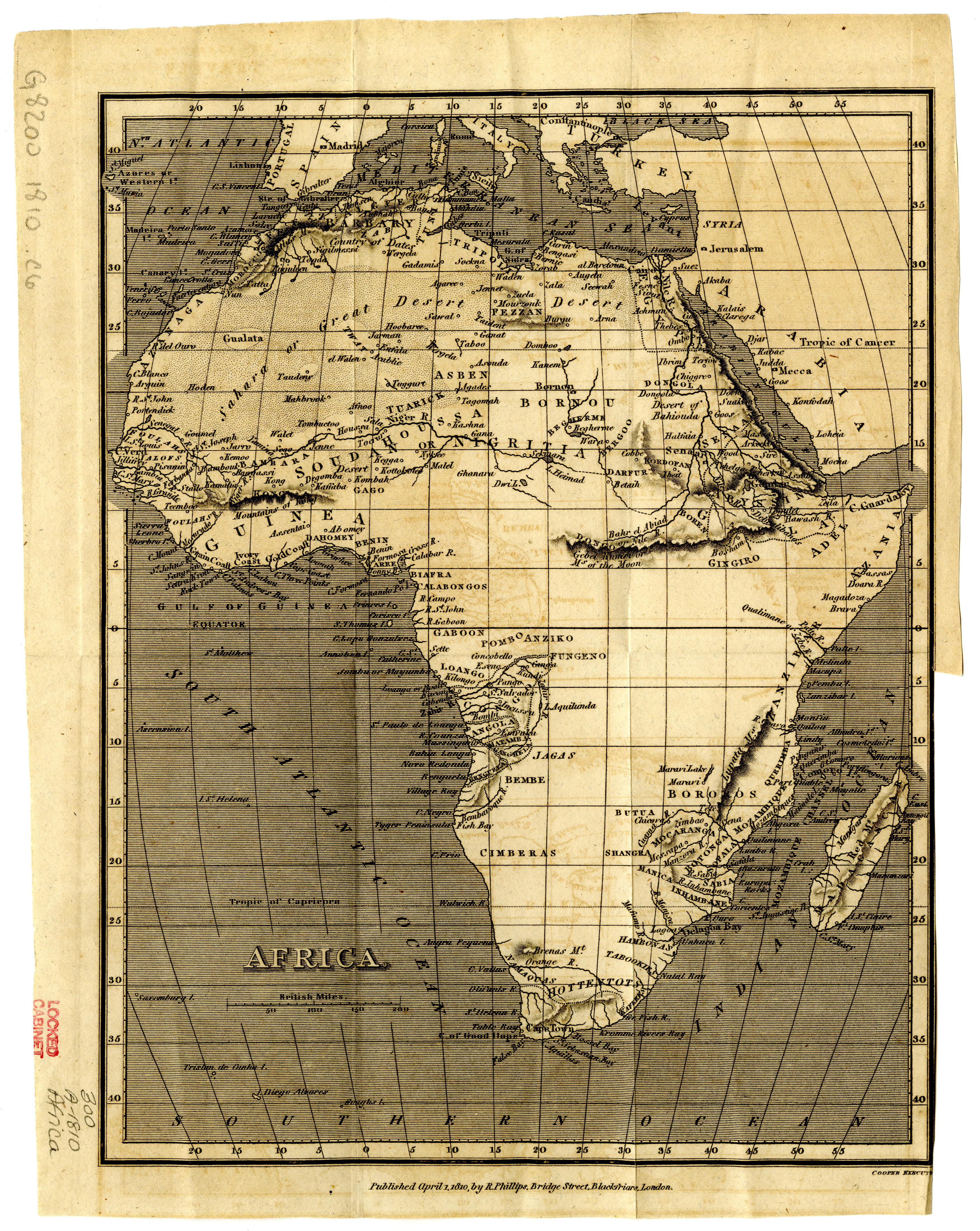
1810 Map 8

Africa. By Cooper. Published in London by R. Phillips in 1810. Michigan State University Library. http://archive.lib.msu.edu/maps/MSU-Scanned/Africa/300-A-1810Phillips.jpg

SOURCE: Michigan State University Map Library
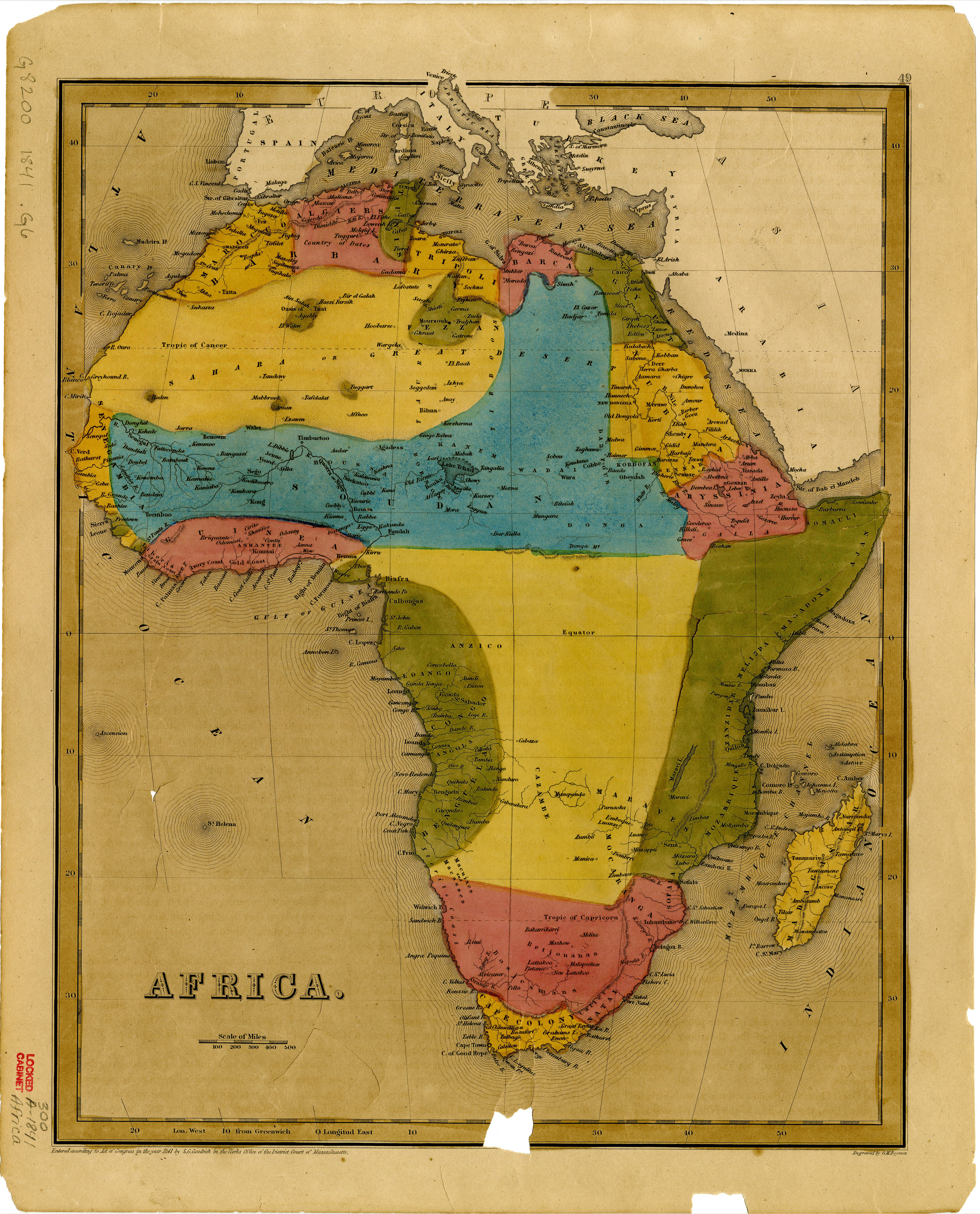
1841 Map 9

Africa. By Samuel G. Goodrich, George W. Boynton, and Charles D. Strong. From General Atlas of the World. no. 49, http://archive.lib.msu.edu/maps/MSU-Scanned/Africa/300-a-1841-300.jpg

SOURCE: Michigan State University Map Library
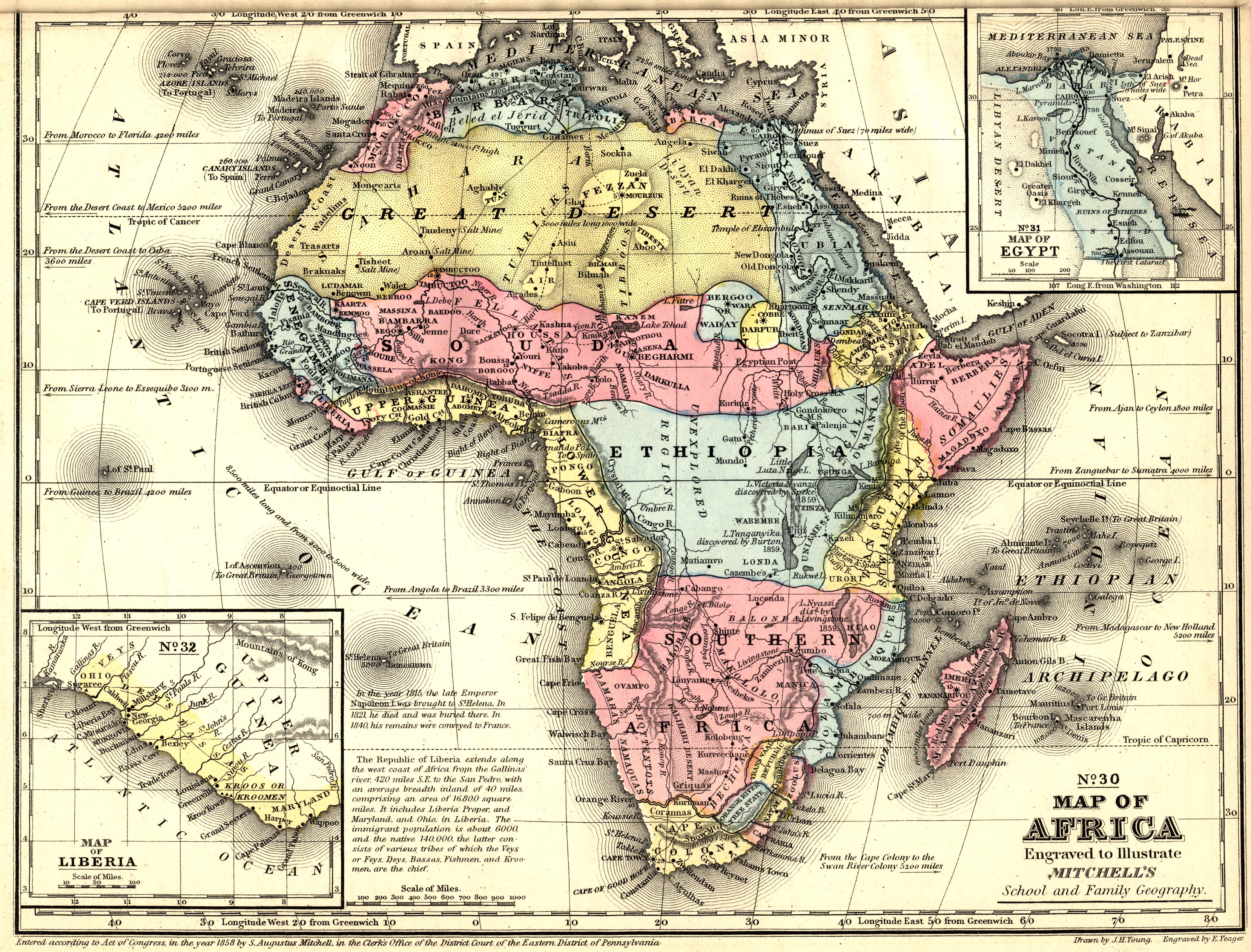
1849 Map 10

French map of the Gulf of Guinea from 1849.
The Bodleian Libraries, Oxford https://wiki2.org/en/File:Gulf_of_Guinea_Guillaume_Lavasseur_de_Dieppe_jpg
French map of the Gulf of
Guinea from 1849. The Bodleian Libraries, Oxford
This 1849 map is
important for its simplicity. Only very important landmarks are indicated. The
three most important kingdoms in that part of Africa are indicated in the map.
One of the three is Biafra.
1867 Map 11


SOURCE: Michigan State University Map Library
1871 Map12

Africa and Cape Colony Map (Gall and Inglis 1871). The Philatelic Database: http://www.philatelicdatabase.com/africa/africa-and-cape-colony-map-gall-and-inglis-1871/

SOURCE: The Philatelic Database (www.philatelicdatabase.com/)
1874 Map 13

1874 Map, Africa. Gray, Ormando Willis. David Rumsey Historical Map Collection. Philadelphia.Gray's Atlas Map of Africa, https://www.davidrumsey.com/luna/servlet/workspace/handleMediaPlayer?lunaMediaId=RUMSEY~8~1~206913~3003061

SOURCE: David Rumsey Map Collection, Cartography Associates
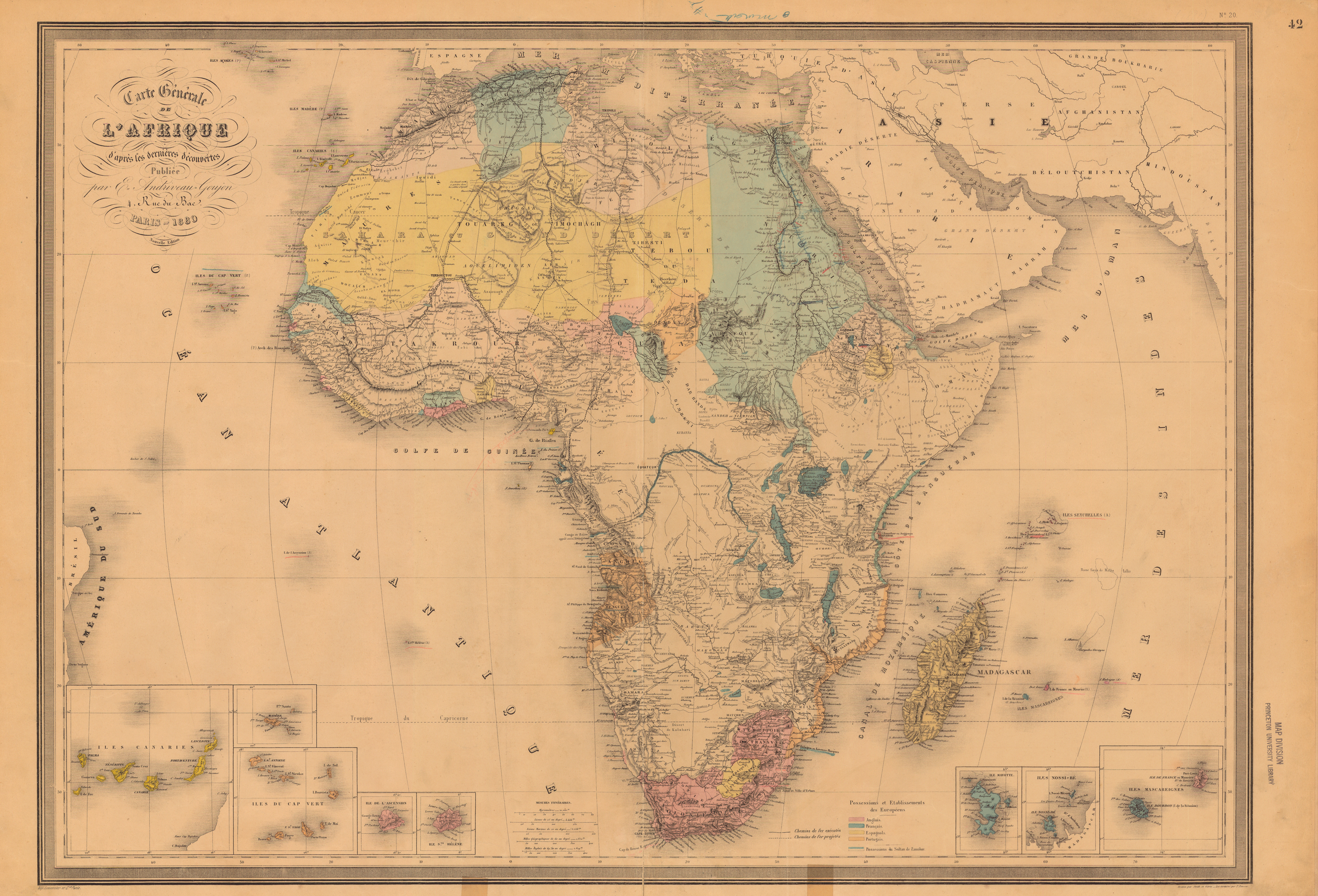
1880 Map 14

1880 Map. Andriveau-Goujon, E. (Eugène), 1832-1897. “Carte générale de l’Afrique, d’après les dernières découvertes…” https://libweb5.princeton.edu/visual_materials/maps/websites/africa/maps-continent/1880%20andriveau.jpg

SOURCE: Princeton University Library
This 1880 map of Africa is the most notable before the Scramble for Africa began. It diligently depicts the ethnic nationalities in the African kingdoms or empires. The scramble led to the 1884-1885 Berlin Conference where Africa was carved out into European style countries without regard to ethnic boundaries and cognate relationships. Biafra was affected. Except for the preservation of the name “Bight of Biafra”, there was complete destruction.
DESTRUCTION
It
was all going well with us until as recent as the end of the 19th
century when European countries started developing increased interest in the
natural resources of Africa and in Africa as large market for their products of
The Industrial Revolution
The Berlin
Conference
“The Berlin Conference of 1884–1885 marked the climax of the European
competition for territory in Africa, a process commonly known as the Scramble for
Africa. During the 1870s and early 1880s European nations such as Great
Britain, France, and Germany began looking to Africa for natural resources for
their growing industrial sectors as well as a potential market for the goods
these factories produced. As a result, these governments sought to safeguard
their commercial interests in Africa and began sending scouts to the continent
to secure treaties from indigenous peoples or their supposed representatives.
Similarly, Belgium’s King Leopold II, who aspired to increase his personal
wealth by acquiring African territory, hired agents to lay claim to vast tracts
of land in central Africa. To protect Germany’s commercial interests, German
Chancellor Otto von Bismarck, who was otherwise uninterested in Africa, felt compelled
to stake claims to African land.
“Inevitably, the scramble for territory led to conflict among European
powers, particularly between the British and French in West Africa; Egypt, the Portuguese, and
British in East Africa; and the French and King Leopold II in central Africa.
Rivalry between Great Britain and France led Bismarck to intervene, and in late
1884 he called a meeting of European powers in Berlin. In the subsequent
meetings, Great Britain, France, Germany, Portugal, and King Leopold II
negotiated their claims to African territory, which were then formalized and
mapped. During the conference the leaders also agreed to allow free trade among
the colonies and established a framework for negotiating future European claims
in Africa. Neither the Berlin Conference itself nor the framework for future
negotiations provided any say for the peoples of Africa over the partitioning
of their homelands.
“The Berlin Conference did not initiate European colonization of Africa,
but it did legitimate and formalize the process. In addition, it sparked new
interest in Africa. Following the close of the conference, European powers
expanded their claims in Africa
such that by 1900, European states had claimed nearly 90 percent of African
territory”1.
1890 Map 15

1890 Map. The Philatelic Database, http://www.philatelicdatabase.com/wp-content/uploads/2008/05/africa-map-

1890.jpg
Five years after the Berlin Conference, the scramble for Africa by the European countries of the conference has advanced. Many of the regions containing autonomous indigenous nationalities have been balkanized arbitrarily, parts ceded to competing countries without regard to the history and identities and autonomy of nations in these lands or to their compatibility with nations combined with them to form the emerging colonies. New countries were already shaping up by 1890 and the effacement of indigenous identities of bona fide African nations was already underway.
Some
areas can already be seen definitely marked for some European countries and
others marked “unexplored”. Biafra has been cut in two, the part in the present
day Nigeria falling into the land ceded to Britain and marked “Br” in this 1890
map. The other part of Biafra located in the present day Cameroun and
Equatorial Guinea, and still identified as Biafra in this map, falls into the
area ceded to Germany and marked “German”. The area of present-day Gabon is
marked “French” in that map
1897 Map 16

By
1897 Africa was already partitioned out for European countries: Belgium,
Britain, France, Germany, Italy Portugal, and Spain. Cameroon became a German
colony in 1884, as Kamerun, but became shared between France and United Kingdom
after the First World War, as United Nations Mandate areas. Final re-assortment
took place in 1960. Equatorial Guinea was partitioned to Spain and Gabon to the
French. West Biafra was severed from Biafra Kingdom and became part of Nigeria.
Biafra became effaced from Map of Africa. This
is complete Destruction.
20th Century
1913 Map 17

1913 Map. In A literary and historical atlas of Africa and Australasia,
http://img.lib.msu.edu/branches/map/AfJPEGs/18-19_g2445b3_l.jpg

Africa is essentially completely shared up. Nigeria is almost the present shape. So are Cameroon and Gabon. North and South of Nigeria are still separate states here. The demarcation is shown and the North is here called “Hausa State”.
Amalgamation of Southern Protectorate and Northern Protectorate the next year (1914) would form Nigeria the way we now know it and the Western part of Biafra Kingdom is included in the Southern Protectorate of Nigeria and would become Eastern Region of Nigeria. Biafra as a name of a homeland is now completely effaced from the map of Africa. Like the Benin kingdom and Bight of Benin, Bight of Biafra marks the coastline and identifies the location of the Biafra homeland:
There
is a homeland whose name as a nation was effaced from the map of Africa as an
aftermath of balkanization and colonization of Africa resultant from the
agreements of some European countries at the Berlin Conference of 1884-1885.
That homeland sits on the Atlantic Ocean with its shores defining the Bight of
Biafra and stretching from the Niger Delta in Nigeria to Ogowe Delta in Gabon.
Seen, therefore, to belong to Eastern Nigeria, Cameroun, Gabon and Equatorial
Guinea is the Bight of Biafra. This homeland is Biafra.
1922 Map 18


SOURCE: Michigan State University Map Library
Historical map of Africa has essentially reached its definitive state here (1922). Nigeria has become a true federation consisting of three federating regions: Eastern Region, Western Region and Northern Region. Midwestern region was later created.
Eastern Region seceded from Nigeria in 1967 and was appropriately named Biafra. That Biafra was reintegrated into Nigeria in 1970. It is unfortunate the name Biafra did not persist after the reintegration..
Bight of Biafra was removed, by Nigeria, from the map, in 1975, through a Nigerian decree that renamed it Bight of Bonny. This renaming is inappropriate because Bight of Biafra, like Bight of Benin, is a name that represents part of a vast homeland while Bight of Bonny reflects the name of just a city in Nigeria.
The renaming was unnecessary and an overreaction because the name Biafra did not cause the 1967-1970 civil war which was blamed on secession. If the Eastern Nigeria had been named Biafra, as appropriate, to be the name of the federating unit at independence the idea would have, probably, been hailed. Bight of Biafra was, therefore, not the problem, existed before Nigeria came to being and continued to exist thereafter without causing any problems.
Nigeria
does not have the right to rename Bight of Biafra which is a name belonging to
the bay shared by multiple nations and reflecting the identity of the bona fide
homeland of those multiple nations – Eastern Nigeria, Cameroun, Gabon,
Equatorial Guinea and several island nations that identify with a broad Biafra
bay as the location of their home, and which is not the bay of a city in
Nigeria called Bonny. Nigeria does not have the right to rename part of another
country; Bight of Biafra is also a part of Cameroun, Gabon and Equatorial
Guinea. These countries and the whole of the International Community should ignore
the renaming and maintain the Bight of Biafra status quo. Gladly, it is largely so as Bight of Bonny is not
recognized internationally.
21st
Century
2015 Map 19

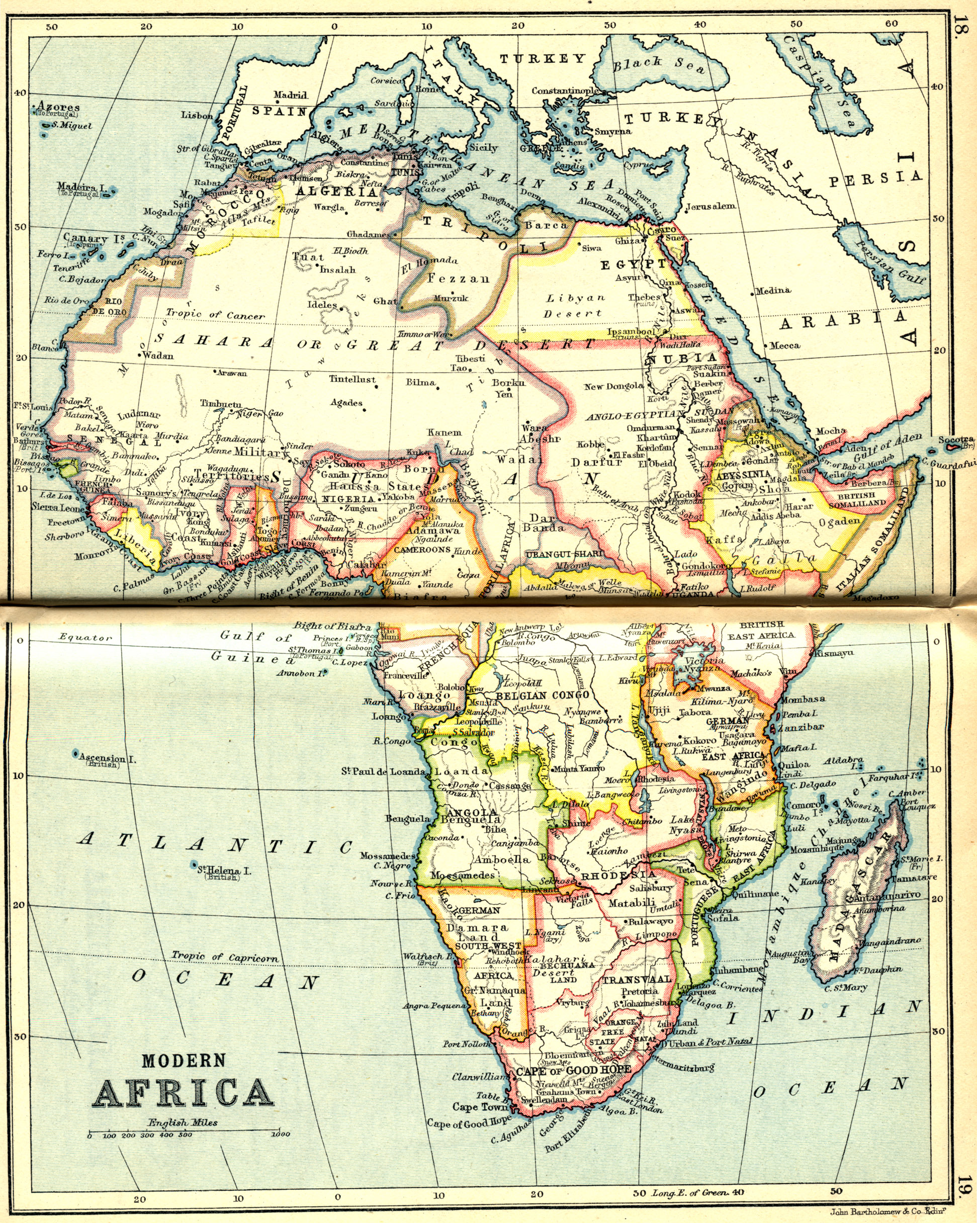
2015Map. Modern Africa, Stamp World History, Maps, Modern Africa: http://www.stampworldhistory.com/maps/continent-maps/modern-africa/
The present map of Africa contains a Nigeria that has a unitary government calling itself a federation. It now has 36 states, and a Federal Capital Territory, which has the status of a state. The states are not autonomous to a discernible extent: they do not have own separate constitutions, do not have control over their lands and resources and are totally dependent on the central government for every need with the centre retaining most power. This number of states and their distribution easily obliterated regional divides and has been as effective as the European balkanization of Africa in effacing the 1967 Biafra from the map and that seems to have really been the principal reason for starting state creation in the first place, adding the giving of sense of belonging to the minority groups.
Biafra was, therefore, not supposed to be an issue anymore. Has it worked? Agitation for self-determination by actualization of a sovereign state of Biafra is thunderously loud and growing yet louder.
The
existence of a vast homeland called Biafra has been traced to as early as the
1584 map. It shows that Biafra was already a large kingdom by the 16th
century. The extent of the kingdom seems to have shown some variations down the
years and it seems likely that the variations reflect the state of knowledge of
the people and the area by the early European travelers and explorers as well
as the European map makers. As knowledge improved progressively down the years,
map-making technology also improving, the relative extent and location of
Biafra kept sharpening along and has been relatively consistent from the very
early understandable map-making inaccuracies, through the post 1885 European
scramble, balkanization, colonization and name-effacement when the extent and
location of Benin and Biafra kingdoms became virtually reflected only in their
Bights which, indeed, provide sufficient landmark, using the knowledge of
historical geography, for its retrieval.
RETRIEVAL
Present African countries are artificial creations of the Europeans. Many of the internal conflicts in most of these countries are as a result of the incompatibilities of various parts joined together to form doomed amalgamations called countries.
It also does not make sense to say your country gained Independence from the colonialist country when it is still bearing the name given to it by them. The words of Dr Sukarno, the first president of Indonesia are transcendental truth:
“. . . slaves and dogs are named by their masters. Free men name themselves”2
It is not adequate to accept any kind of country they left behind for us, different from the homeland we had before colonization: many times what was left behind was no more complete and some of our kindred tribes and clans were no more there. Things are worse with such kindred groups joined with incompatible, hostile or unfriendly groups, some of which have strange cultures and mindsets; they have faced resultant insurmountable difficulties over many years.
Some of the colonizing countries also left behind situations that provided avenues through which they continued, furtively, to exercise some control over African countries. This has had, in some instances, unwholesome economic, political and cultural influences on the African countries, and they, most times, do not know what is really wrong with them. The fact is that they are not yet economically, politically and culturally free and self-realized. They are still being controlled through some vestige, innocuous-looking links that are very powerful tools in reality. The solution is for African countries to realize complete independence and take complete control of their nations in every way. We must shake off all shackles of colonialism and make sure that there is none of it left behind.
It might not be easy for people to understand the extreme importance of this, but it seems Ahmadu Ahidjo, the former president of Cameroon, did know it, and did feel it deeply, to make him change the colonial name Victoria City of Cameroon to Limbe. So sweet and beautiful was that action that it quickly resonated with the whole world. They now feel something special going to a wonderful city that is really African, and expecting an authentically African sights and sounds, a beauty that is truly African and a traditional African reception, all of which they cannot get in their usual stereotype destinations which have names like a Victoria that is stiff-necked British. The expectation starts with the name and Limbe eventually fulfills their expectations, of a very enriching African experience.
Why would anyone want to retain a European identity for an African reality?
Hon. Justice R. N. Onuorah told an important story
in his Foreword to the book Ogwugwu
Ntegbe: “Glanville William (African American), in his book ‘The Destruction
of Black Civilization’, gave an account of a traveler who encountered a lonely
child roaming a desolate area. The traveler confronted the lonely child with a
question why he was walking aimlessly about the area. The child answered him
that all his people who inhabited that area died. The traveler was dumbfounded
and before he could utter another word the lonely child told him that his
people had died because they forgot their history. The traveler went blank and
before he could recover, the lonely child disappeared”.
They
died because they forgot their history!
There is a large wave of identity consciousness going on across the globe, with peoples desiring and pursuing self-determination in various forms. In many countries and regions, the interest is in tracing their bona fide identities and adopting same as the defaults. These exercises have so far resulted in very positive effects in terms of the energy engendered by such realizations and the pride in such realized lofty identities that make them work very hard in line with the greatness they would want their beloved homeland to be in its realized real and cherished identity.
This
has happened with some countries and they replaced the names given to them by
the colonialists with names from their bona fide homeland identities. Some of the countries adopted the names of
their bona fide homelands that existed in their present locations and a few
others replaced their colonial names with the names of their bona fide homelands
from where they migrated to their present locations.. Here are a few examples:
BENIN
Republic of
Benin understood the importance of removing all vestiges of colonialism and
imprints or watermarks of past conquests and dominations of them. This helped
to properly orientate the people, galvanizing them into self-realization and
towards nationalistic, devoted, progressiveness:
There was a Kingdom of Dahomey that existed from 1600 to 1894. King Behanzin was defeated by the French in 1894 and so was the last king of the Kingdom of Dahomey. The kingdom ended and became part of the French colonial empire. “During the colonial period and at independence, the country was known as Dahomey. On 30 November 1975 it was renamed to Benin, after the body of water on which the country lies - the Bight of Benin - which, in turn, had been named after the Benin Empire.”3
Benin Empire started from the west bank of the post-confluence north-south section of the River Niger which separated it from the Biafra Empire to the east. It reached down to the Atlantic coast and stretching westward to cover the whole area of present-day Western Nigeria (including the Mid-Western Region) and the present-day Republic of Benin, was exactly lying on the Bight of Benin, the coastline of which continues eastward with that of the Bight of Biafra on which Biafra Empire lies.
It
is clear from this account that Domey was the name given to their land by
their conquerors and their colonizers and so they rightly changed their name to
that of their bona fide homeland, Benin, which is also their default homeland.
GHANA
The name given to Ghana by the British colonialists was Gold Coast and the reason is evident. That was the name of that country until their Independence in 1957 with the revolutionary and Pan-Africanism advocate, Kwame Nkrumah, as their first Prime Minister and President. It is not surprising such a person spearheaded the change of the name of the country successfully in a Ghana whose citizens are generally proud of their past. They changed the name to that of their bona fide homeland from where they had migrated centuries ago.
The demise of Ghana empire was due to mass migration when the land progressively became inhospitable presumably due to desertification, although interesting stories and legends surround it, essentially depicting lack of knowledge of scientific events at that time. The bottom line in all the accounts is that the land became infertile.
The
word "Ghana" was derived from Ga’na which is the title for the king
of the Soninke people of ancient Ghana Empire, the ancestors to the Akan people
of modern-day Ghana. It meant "Warrior King. They were a great trading
nation and the land was then fertile and rich in gold and iron; they had strong
warriors that were able to defeat the marauding Berbers of North Africa and
successfully defended their established kingdom with its imperial capital at
the gold mine city, Koumbi Saleh. It can easily be seen why Ghanaians are proud
of their bona fide identity and decided to adopt the name of their bona fide
homeland although they do not reside in that location now and may never migrate
back there, and it cannot be their default homeland.
ZIMBABWE
Republic of Zimbabwe was Rhodesia at Independence in 1965, which was declared unilaterally by the conservative white minority government then led by Ian Smith.
Southern Rhodesia, established in 1898, became Rhodesia in 1965, and Zimbabwe Rhodesia 1979. The 15-year international isolation and black-nationalist freedom fight resulted in a peace agreement followed by establishment of a universal enfranchisement and sovereignty as Zimbabwe in April 1980.
Zimbabwe became the name of the black majority
government led by Robert Mugabe. It remains to appreciate why “Zimbabwe” was
chosen in the first place.
The most prominent pre-colonial civilization in
southern Africa, Zimbabwe’s name is derived from one of two possible terms: Dzimba
dza mabwe or "great stone houses" in Shona language or Nzi we mabwe or "Homestead of
Stone" in kalanga
language. The Kingdom of Zimbabwe existed
from 1220 to 1450 and was a medieval kingdom located in the place occupied by
modern-day Zimbabwe with a capital called Great Zimbabwe, and known to be a
large stone structure that has none of its kind. The Kingdom of Zimbabwe, as
suggested by archaeological excavations in the region is likely to have been
much more ancient. Present-day Zimbabwe has been the site of several
established kingdoms since the 11th century, and was renowned for its trade
routes, for gold, with Arabs.
Zimbabweans must be proud to be known by the name of
such a distinguished bona fide homeland of theirs.
NAMIBIA:
South West Africa was the name Namibia bore since when present international boundaries were established by German treaties with Portugal and Britain, 1886-1890, and Germany annexed the territory as South West Africa4
Namibia is derived from the Namib Desert, the oldest desert in the world. Namib, is a word that is of Nama origin and means "vast place"
“The world's oldest desert, the Namib Desert has existed for at least 55 million years, completely devoid of surface water but bisected by several dry riverbeds. These riverbeds are vegetated and are home to a few ungulates, such as Hartmann’s zebras. The south of the desert is extremely dry and even lacks dry riverbeds; gemsbok is the only large mammal to occur in this harsh environment. Thick fogs are frequent along the coast and are the life-blood of the desert, providing enough moisture for a number of interesting, highly-adapted animal species to survive.”5
Here is how Namibia got its name from Mburumba Kerina:
“Kerina was able to study in Indonesia, under the
fellowship of Dr President Sukarno, and he was invited to have tea with Sukarno
in his palace. ‘We talked about his country and mine as well. He asked me,
“What is the name of your country?” I said, “South-West Africa”.
‘That's
not a name, that is a geographical area. My son, slaves and dogs are named by
their masters. Free men name themselves.’
“This inspired Kerina's search to rename South West
Africa soon after this inspiring conversation . . . . .
“Kerina realised that Namibia was going to be
annexed one day, and it would be the end of Namibia. Soon after, he wrote an
article that their country should be named the 'Republic of Namib' and the
nationality of the people must be referred to as Namibians. ”2
“That gave us
an identity internationally when the United Nations adopted this name with the
support of our party, SWAPO. The name became so popular that we couldn't find a
better name.”5
This is yet another moving example of identification
with a bona fide homeland name. This is not identification with the land for
its richness or prosperity of its inhabitants, although diamond was discovered
along the line. They, in fact, identified with aridity and a terrain of
challenge which that name stood for; but great love resonated in their
identification. A love that is real, true and divine for it is unconditional,
as it should be, for it is their bona fide homeland name they discovered.
The examples here are African countries. The
destruction of identity and heritage by colonizers happened almost exclusively
in Africa. African nations owe it a duty to themselves to recover their lost
identities, rediscover their heritage and fully reclaim their nations. So is
expected of Biafra.
Biafra has been a relatively very peaceful homeland
with a stable polity, dating back to available written records. There are no
records of Biafra engaging in the conquest of other nations, neither do we have
records of they being conquered by any of the marauders. It also seems they
have been industrious and adventurous people as deductible from depictions of
early explorers, travelers and cartographers The size and the relationships of
Biafra in historical maps of Africa have remained the same from as early as
1584, corrected to the extent of accuracy which continuously increased over the
years with increase in knowledge and technology.
A great kingdom was lost to European balkanization
and colonization. Since this is a recent event, it is still easy to recover the
kingdom in its entirety and in all its power and glamour, with a capacity to
take a premium position among first-class nations of the world. This can be
achieved by retrieving the kingdom in a Biafra Federation.
Retrieving our African borders is what is at issue
here. This can be done by getting leaders of the component nations to
understand that Biafra Kingdom is their bona fide homeland that was destroyed
to create their smaller countries, effacing their common great name. Arbitrary
European borders separated Africans of the same heritage and severed off parts
of native homelands, merging them with some other, sometimes incompatible,
parts.

Same ethnic groups bisected by the European arbitrary boundary. Relatives thrown into different countries. https://en.wikipedia.org/wiki/Ekoid_languages#/media/File:Map_of_the_Ekoid_languages.svg
Countries separated
arbitrarily in Biafra, as already implied in the Historical Geography, earlier
presented, are Gabon, Equatorial Guinea, Cameroon and the westernmost part of
Biafra which is a part that was severed off and merged with other incompatible
parts to form a resultantly very unstable country called Nigeria. This became
Eastern Nigeria in a British colony while the other three countries arbitrarily
created by European acquisition and ceding processes became colonies of three
different European countries in that mad rush for pieces of Africa.
This westernmost part of Biafra which was in the
Nigeria contraption of the British is hereinafter known as West Biafra. It was
West Biafra that drew our attention to the name of our great common homeland.
As Eastern Nigeria which suffered perennial mistreatments that reached
unbearable level in 1966 and continued thereafter, in that typical example of a
doomed amalgamation that is Nigeria, it seceded from Nigeria in 1967 and
appropriately took up Biafra as the name of the emerging country. Appropriate,
because the entire Eastern Nigeria is Biafraland, the western part of Biafra
Kingdom, where the coastline of Bight of Biafra begins, then continuing as the
coastline of Cameroon and Equatorial Guinea and ending as the coastline of
Gabon. A well-known history is the
genocidal war against that Biafra, forcing West Biafra to be reintegrated into
Nigeria in 1970.
Biafra Federation shall consist of Gabon, Equatorial
Guinea, Cameroon and West Biafra. This is a formidable union that will
perfectly retrieve the glorious Biafra Kingdom in its modern format, the Biafra
Federation. Biafra Empire, Biafra Kingdom and now, Biafra Federation, are one
and the same in content and extent.
The
names, “Cameroon” and “Gabon” need not be changed. Equatorial Guinea is the
very appropriate name the people gave to themselves, which replaced their
colonial name. What is an important fact is that these four units existed
inside Biafra Kingdom and that Biafra is their bona fide and default homeland11.
They only need to be part of a federated union of independent states, the
united states of a Biafra Federation.
An example of difficulties created by the European
arbitrary borders is found in the movements of Northern and British Southern
Camerouns in and out of Nigeria:
“The United Nations organized a plebiscite in the Cameroons
on 11 February 1961 which put two alternatives to the people: union with
Nigeria or union with Cameroun. The third option, independence, was opposed by
the UK representative to the UN Trusteeship Council, Sir Andrew
Cohen, and as a result was not put. In the
plebiscite, Northern Cameroons voted for union with Nigeria, and Southern
Cameroons for union with (the formerly French) Cameroun”6.
Nigeria and Cameroun gained Independence in 1960 and
this necessitated the UN-organized referendum to determine the fate of the two regions
which were part of Nigeria administered by the British-ruled Nigeria as British
Cameroons, a United Kingdom Trust Territory of the United
Nations, which participated very actively in Nigerian politics, Southern
Cameroon having had thirteen members in the Eastern Nigerian House of Assembly
at Enugu.
Another
example is found in the Bakassi conflict:
“When the nations of Nigeria and Cameroon
went to settle a border dispute in 2002, in which both countries claimed an
oil-rich peninsula about the size of El Paso, they didn't cite ancient cultural
claims to the land, nor the preferences of its inhabitants, nor even their own
national interests. Rather, in taking their case to the International Court of
Justice, they cited a pile of century-old European paperwork.
“Cameroon was once a German colony and
Nigeria had been ruled by the British empire; in 1913, the two European powers
had negotiated the border between these West African colonies. Cameroon argued
that this agreement put the peninsula within their borders. Nigeria said the
same. Cameroon's yellowed maps were apparently more persuasive; it won the case
- - -”7
So,
also, are the historical maps, here presented, extremely persuasive - that
Biafra Kingdom was a great homeland of ours that existed for centuries, until
recently, and needs to return as Biafra Federation and that West Biafra(Eastern
Nigeria) is part of it.
The fact of the conflict is that Bakassi
people are neither Cameroonians nor Nigerians. They are Biafrans, just like
Cameroonians and Eastern Nigerians are but the European boundary, which sliced
out part of Biafra into Nigeria has put those brothers and sisters of ours into
the untold difficulties they have found themselves now, their real relatives
(Cameroon and West Biafra) not caring enough for them. It is my view that
Cameroon and Eastern Nigeria should liaise and take good care of them and stop
waiting for a Nigeria that is alien to them and does not care about them.

The Nigera-Cameroon Border Region. 1963 Map https://en.wikipedia.org/wiki/Bakassi#/media/File:Cameroon_Nigeria_border_coast.jpg Remove that border line, everything you are seeing is Biafra
In the case of transfer of the sovereignty of
Bakassi Peninsula from Nigeria to Cameroun as a result of a judgment by the International Court
of Justice8, the
Nigerian Senate said, on November 22 2007, that the Greentree Agreement ceding
the area to Cameroun was contrary to Section 12(1) of the 1999 Constitution,
and rejected the transfer9 The territory was transferred to Cameroon
on 14 August 2008 in spite of the rejection10. This action of the International Court of
Justice proves that provisions of Nigeria’s constitution can be overridden or
ignored by an International Court of Justice, depending on the nature of the
judgment. It is the same 1999 constitution that has been the stumbling block to
self-determination sought by the people of West Biafra, for not providing for
referendum11. West Biafra
cannot be prevented from being part of the Biafra Federation as the
consideration will be an international business at the United Nations and, if
necessary, the International Court of Justice.

https://en.wikipedia.org/wiki/Bakassi#/media/File:Un-bakassi.png
It is a duty we owe to the
world to retrieve and showcase this special homeland which was a kingdom of
peace and prosperity and which now has a special potential and a confirmed
capability to become a masterpiece Federation of champions.
FEDERATION OF CHAMPIONS
This project involves consultations with other
countries that are in the bona fide Biafra homeland, to retrieve the Biafra
homeland in its entirety, and form a Biafra Federation with the individual
nations in the homeland, developing a good formula to forge a workable union.
The bona fide membership of the Federation comprises the nations in West Biafra
(Eastern Nigeria), Cameroon, Gabon and Equatorial Guinea. This is a federation
of champions.
The four units are already champions in every sphere
and now the limit is beyond the sky. They have the capacity, individually and
collectively, to produce one of the world’s top economies. Economic success is
hinged mainly on the pillars of Availability of Material Resources,
Availability of Human Resources and Existence of Appreciable Peace, intra- and
inter- unit. All these are richly available in the Biafra Federation.
The trappings are evident and brightly suggestive.
They will be more than able to put these available pillars to advantageous use.
Economy grows when monitory policy is good and there is a good level of
production. Brains are not lacking for the right economic management and they
have potentials to do well in all the areas of Agriculture – Crop Farming,
Animal Farming, Forestry etc., and in Manufacturing; they have a good
technological knowledge base to drive these endeavours to appreciable heights.
Other important areas such as Sports, Entertainment and Tourism are already
where each of these units are experts in and in which they have very great
potentials for exponential development.
Our abilities in Agriculture are not in doubt and we
have little else to prove, only that we need to improve more, modernize more
and make it a very important economic driver. Our great prowess in Technology
and Manufacturing is, however, not as evident as it is really true, the
potentials also being very great. A lot is happening in all the units. I come
from West Biafra and I can give an example with the situation there. Enugu has
a lot of industrial hubs engaged in manufacturing, and it is surprising, for
instance, what happens in such a small place like Tinker, in the industrial
area of Coal Camp Layout of Enugu, where virtually everything can be fabricated;
the automobile assembly industries in Enugu and other parts of West Biafra have
large percentage of local content.
Nnewi town is one huge industrial and commercial complex with an incredible level of manufacturing going on there; it is fondly called the Japan of Africa. Onitsha is the foremost commercial town in Africa and also a great industrial area too. High quality Made in Aba products are invading world markets. Many other cities in West Biafra, such as Port Harcourt, Awka, Owerri, Calabar etc., have their specialties in industrial development.
There is no surprise that much if it is recalled what West Biafra achieved as “Biafra” during the war with Nigeria. We manufactured arms and equipment in that state of war, in spite of the blockade, and refined crude oil into petroleum products, without an established refinery. Nigeria can still not manufacture arms fifty-one years thereafter and still imports almost all her domestic needs of petroleum products. They had declined to work with our war technologists to the benefit of Nigeria, as proposed by Sam Ogbemudia who, “as military governor of the Midwest had quickly made contact with the now late T.E.A Salubi and Dr. Nwariaku, one of the great Biafran scientists, and a key figure of the Biafran Research and Production (RAP) department whose innovations in war production gave insight into the capacity of the black mind, and quickly made a case at the Council of States for the Gowon administration to urgently gather these scientists, rehabilitate them, and use RAP as the basis for Nigeria’s industrial revolution”12.
Similar stories exist in other units
in the Biafra Federation. Excellence is in Biafra’s DNA. We have all the
ingredients for a great industrial revolution in the Biafra Federation, which
will astonish the world.
How many nations or federations or even regions have done as well as Biafra Federation in sports? For instance, 15 times have Biafrans won the African Footballer of the Year award out of a total of 48 times (31.3%). Only once has a non-Biafran won it in Nigeria (Victor Ikpeba). National soccer teams in the Biafra Federation have done well in the African Nations Cup much more than others have. Evidently, we stand very tall in all the other sports.
Nigerian film industry which existed since more than
40years ago was essentially born in 1992 with the entry of Biafrans with the
landmark film “Living in Bondage” which is popularly regarded as the first film
of universal appeal, nationally, then internationally, and the film that
launched Nollywood although that name was given to the industry in 2002 by an
international commentator on films. Previous projects were over-localized in
terms of content and so were little known. When Biafrans came on stage, they
quickly included other Nigerian technical experts, fashioned out a business
model and a production technology that resulted in the explosion of the
Nigerian film industry with minimal resources, to how we know it today.
The four units are known globally for their unique
types of music, the wonderful art forms, the energy and the grace they bring
into entertainment with music. They are outstanding in the business aspect of
it.
Tourism potential is what the Biafra Federation has
in abundance and which is already blossoming, with very little exploitation so
far. What about when four heads, instead of one, find solutions? Does that
simple adage not say that “two good heads are better than one”?
Champions
shall be pulling efforts together in the United States of the Biafra
Federation. Modeled similar to the United States of America, each unit shall be
a standalone autonomous state; and like the United States of America, the union
shall be a phenomenal success.
Biafra is our common heritage. This is a homeland
that God has so lavishly blessed with human and material resources and
positioned it to be in the eye storm for all the good reasons, to be the heart
of the universe and to be at the center of the world.
CENTER OF THE WORLD

Modified from https://www.mymapman.com/main/classroom-maps/classroom-national-geographic/1-map-world-kids-political-detail
Biafra Federation
The black patch at the center of Africa, Africa
which is at the center of the World. (Satellite
black dots in the bay are included).
Biafra Federation - The dark green patch in Central Africa, at the center of Africa, at the center of the world


The
best of things are found at the middle and not at the extremes. The Biafra
Federation is located in the center of the world, a superb geographical belt,
equatorial and tropical, with the best climate and vegetation, generously
endowed with natural resources, all the federating units having access to the
sea at the Bight of Biafra as they are all linked by a long continuous
coastline, assuring the Federation an enviable maritime geography


The constituent islands within the Bight of Biafra
and the vast coastline provide great opportunities for lots of tourist
destinations. When Fernando Po, the Portuguese explorer, discovered Bioko
island of Equatorial Guinea in 1472, the name he gave it was “Formosa”, which
means “Beautiful” and this tells a lot about that beautiful island which was
later popularly called Fernando Po, after the explorer himself. That is how people get entranced by that
exquisite beauty of nature.
Other islands in the bay are each uniquely endowed
and breath-taking themselves. They are already choice destinations for many
tourists worldwide.

Bonny Island, West Biafra (http://ng.geoview.info/bonny_island_jv_camp,2895119p )

Bioko, Equatorial Guinea (https://www.traildino.com/trace/continents-africa/countries-equatorial_guinea )

Annobon Island Equatorial Guinea (http://www.mvmtravel.com/places-to-visit/equatorial-guinea/ )

Elobey Grande and Elobey Chico Off Gabon (http://ga.geoview.info/elobey_grande_and_elobey_chico,11337649p )

Sao Tome off “the Cameroon Volcanic Lines” (https://www.thehotelguru.com/best-hotels-in/sao-tome-and-principe)

Bom Bom, Principe Island of the “Cameroon Volcanic Lines” (https://www.tripadvisor.co.uk/Hotel_Review-g480232-d550937-Reviews-Bom_Bom_Principe_Island-Principe.html )
Prominent among these numerous islands and islets
are: Bonny Island in West Biafra, Bioko in Equatorial Guinea, Corisco off the
coast of Gabon, the so-called Cameroon Lines, Elobey Islands (Elobey Grande and
Elobey Chico), the island nation of Sao Tome and Principe, and Annobon island,
among others. It is hoped that these islands shall constitute a very important
part of the Biafra Federation.
The endowments of the Biafra Federation are like
those of one in the centre of loving attention from more than several sources
and spoilt with abundant rich gifts: warm desert and semi-arid land, scenic
savanna grasslands, ornate deciduous woodlands, lush rain forests and
mystifying mangroves at the labyrinthine creeks, picturesque peaks and
plateaus, plenty of rivers, a good number of them fully navigable while some
are partly navigable, and vast seas with lots of riches therein.
Riches beneath the ground – solid, liquid and
gaseous – are in abundance in every part of the Biafra Homeland with enormous
reserves awaiting value-added exploitation. All the units are already very
prominent Petroleum Exporting Countries.
The enclave is home to a large variety of assorted
wild life, on the loose and in wonderful wild life parks and game reserves, the
islands being the best birding destinations in the world and containing the
rarest and the oldest bird stocks endemic in them13.
If
these joint natural endowments are intelligently put to advantageous use by our
richly-available gifted human resources, Biafra Federation shall quickly become
the very center of world attention.

From daveliggett.com/TravelAfricaGabonPhotoPage1.htm
The endowments and potentials of Biafra Federation are enormous and need to be put into maximum advantage for the benefit of the world. The success in managing these human and material resources hangs on having good governance, without which efforts remain fruitless. We have to get it right from the beginning by adopting the right type of government suitable for a multi-ethnic and beautifully diverse homeland such as ours. Experience from glaring facts, worldwide, shows that it is prudent and expedient to fully adopt True Comprehensive Federalism as it is, in all cases and especially for Africa, the best form of government.
GOVERNMENT
It is believed that agreement will not be a problem
if there is proper knowledge. Making the requisite knowledge available is the
key to the success of getting Biafrans in the various nations cooperate in the
realization of the Biafra Federation. It is expedient for these four units to
forge a union, in a big strong, prosperous, united, truly federal
government.
In terms of compatibility issues, it has to be noted
that the four units have been closely, beneficially, interacting for centuries and a very good
bonding exists between peoples of the units. They are already comfortable homes
to thousands of each other’s migrant citizens. When the Biafra of Eastern
Nigeria was oppressed by Nigeria and conniving World Powers, 1967-1970, many of
those Biafrans became comfortable refugees in the other three countries and
many of them are still living there.
True Comprehensive Federalism is the recommendation
here and this means that each of the four units shall remain autonomous and
federate to form a union – the Biafra Federation - as a platform for greater
economic growth, socio-cultural advancement and political positioning that will
give Biafra Federation, and the constituent states, a most enviable place in
the comity of nations. True Federalism is the most workable form of government
and the easiest to run with the least of conflicts, in a multi-racial,
multi-ethnic multi-lingual and multi-religious homeland like ours and is
recommended for the individual states in the federation and their components
down to the least unit.
The authentic Biafran Identity is like a stunning
image availed through the instrumentality of a superb, properly functioning
kaleidoscope. Colourful entities link with each other, sharing their individual
colours in their different layers of interaction as they move towards the
center to make vital contributions to it.

Kaleidoscope http://kaleidoscope.love/
The
co-operating spheres maintain their splendor, in shape and colour, link up with
each other and enter into a network of relationships with each other, sharing
colours and shapes, producing more different colours and more different shapes
as they happily converge to contribute commensurate percentages of their
properties to the center which equitably radiates gratitude to the federating
units at the periphery.
The properties of each unit are unique to it but
interactions produce a complex mix that is a beautiful eye-catching whole
pattern. The more you look, the less you see differences and the more you
discover beauty.

https://www.britannica.com/technology/kaleidoscope
The
splendor converges to the central focus and is regularly and radially reflected
back to the sources.
You are actually seeing goodness moving round and
round in a broadening gyre that shall have no end.

http://www.nebhe.org/wcontent/uploads/colorkaleidoscope.jpg
Who would not want to be part of this exquisite
beauty, and who would not want to identify with this unity in diversity? There
is this esthetic dazzle that, though easy to behold, is really not easily
explicable. The endowments are unique, severally and also jointly in the
mosaic. Shouting out glaringly are the charming colours but together they do
not run riot. Principalities and powers ponder and wonder – not many dominions
possess such natural attractiveness and obvious prosperity. There is a palpable
display of great might, perhaps vigour, and potency, all in an unfathomable
resplendency also encompassed in a kaleidoscopic complexity that is a simple
beauty.
The more diligently it is dispassionately studied,
the more is exposed, greater diversity, yet much greater unity, more beauty,
visible strength and stability:

https://011art.deviantart.com/art/Psychedelia-38755188
The fact, however, is that this ideal can only be as depicted if the kaleidoscopic view is not from a faulty instrument or a sick eye, in which cases the image is still the same but the viewer’s perception is distorted due either to the false image served him by a spoilt instrument or by what he sees with his faulty eyes. Faulty instrument and sick eye: what can become responsible for any of such situations?
This Biafra Federation, if well-constituted, will easily take care of the self-determination agitations in any of our component units. There will be no need for the agitations anymore for their needs will be well-served in a comprehensive federalism which will happen in all tiers of government, for they will be federated as autonomous units.
For example, West Biafra will be a true federation
consisting of several Provinces therein as federating units. These are Abia,
Akwa-Ibom, Anambra, Bayelsa, Cross-River, Ebonyi, Enugu, Imo and Rivers . Each
province in West Biafra homeland, big or small, will control its resources,
work hard, blossom and contribute proportionately according to size and
according to resources controlled and harnessed beneficially (in other words,
according to the size of their internally generated revenue), to West Biafra
homeland, which will in turn contribute commensurately to the Biafra Federation. This model is what is expected to be put in
place in all the constituent states of the Biafra Federation.
The provinces in each of the four federating states
will also have their constituent units, such as Local Government Areas or
Counties or equivalents, also federating into such a province and communities
federating into the Local Government Areas or Counties or equivalents in a
similar fashion.
A federal government has to be distinguished from a
unitary government which is prone to serious conflicts in a very diverse
country like Biafra Federation. A unitary government is defined as
“characterized by or constituting a form of government in which power is held
by one central authority” (WordWeb). The great danger in this system is that
all the units go to the centre to share a common wealth. There has to be a
formula for the sharing and it can never be satisfactory to all in such a
heterogeneously constituted and configured country like Biafra Federation. There
will be unending conflicts that will keep on creating animosity between the
units, and encouraging the deadly quest for the control of the unduly
attractive centre that may not be able to run away from nepotism.
In true federalism our diversity shall be our source
of great strength. Nobody quarrels as a result of central revenue-sharing in a
Federation because there is no revenue-sharing and each unit is on its own
working hard to generate its own revenue; the federating units, therefore, get
on well in a healthy, strong competition as they work hard to create resources
and have the right to control and harness their units’ natural resources. No
one cries for marginalization in a true federation because each unit is on its
own fending for itself. Nobody agitates for self-determination in a true
federal system because each unit is already autonomous and only pays tax to The
Center for those few but very important mutually-beneficial services rendered
by The Center.
A case for an instance is that of Nigeria which is
currently experiencing many waves of agitations for self-determination and
cries of marginalization because it is now a quasi federation, being called
“Federal Government of Nigeria” whereas it is, practically, a “Unitary
Government of Nigeria”, and was more prosperous when it was a true federation
before the civil war 1967-1970. The clamour for restructuring into true
federalism is extremely loud in Nigeria.
The injustice in the Nigerian situation is that the
wealth being shared is generated virtually solely by the Niger Delta with a
little contribution by a few other viable states and virtually nil contribution
by majority of the states, as they are presumed non-viable. No state can be
non-viable in a Nigeria that is a true federation because the states would have
no choice but work hard to prosper instead of going to sleep guaranteed a share
of the national cake at the Center which they contributed very little in
baking. They are rather motivated on discovering their large unexploited
resources and the great potentials really available to them, and are encouraged
to do very much for themselves and pay commensurate tax to the center for
taking care of essential and national tasks.
No part of Biafra Federation is non-viable in any
way because this homeland is richly blessed all over. A true federation down to
the least level of governance will bring out the best from us. The way to stop
agitations for self-determination through a win-win situation is to grant
autonomy to present agitators and, indeed all of such units, in a true
federalism.
The argument that granting such autonomy will result
in the balkanization of the country is only true in the opposite, provided the
resolution is not by fiat or by force but through sincere brotherly
negotiations with transparent and unambiguous goals in mind, all cards placed
on the table.
Who would not want to be part of a big and
progressive country in spite of being an autonomous unit? Who would not want to
be part of a big market economy and also benefit from other values derivable
from being part of a big and influential country? All the diverse ethnic
nationalities beamed in their real identities on a Biafra Federation screen
would surely present a breath-taking kaleidoscopic beauty, all things being
equal. I daresay that what most of our people want is to be part of the
kaleidoscopic beauty that is the diverse but united, strong, equitable Biafra
Federation as autonomous federating units.
This will
mean that any country in the Biafra homeland still operating the troublesome
unitary government in any guise would consider immediate restructuring to true
federalism and not to leave it too late for hatred and mistrust to have time to
get unnecessarily ingrained into the psychic fabrics of citizens in conflict
areas, leading to an unfortunate, perennial quagmire. We deserve to live in
peace and prosperity in this abundantly God-favoured homeland.
The only persons who benefit from a unitary system
of government where wealth, power and authority are in one source, are the
self-centered and selfish, despotic, evil men who do not have the interest of
anybody at heart. Being very powerful, they easily position themselves at the door
of the store of the common wealth, help themselves to their fill and manipulate
the flow the way they please, which often sees wealth, power and authority
distributed in a provocatively inequitable manner, causing chaos and conflicts
in which environment they thrive in their art. True federalism bye-passes such
persons as wealth, power and authority thus reside in the units on which The
Center rather depends.
Those biting issues that make life difficult for people
in the unitary set up can be easily avoided if Biafra Federation is structured
into a true federation where the federating units are developing independently without
being tied to the dependence on a Center, and so are not affected by the
demeanor of that Center, good or bad, towards any of them; the Centre is
significantly rendered unattractive, stemming the murderous desires and moves
to acquire and control power at the center and the attendant serious
consequences.
CAPITAL:
A prominent city in the
historical maps named Biafra,
inside the Biafra Kingdom, was probably the capital city of the Kingdom and may
be considered as the capital city of the Biafra Federation. It was consistently
depicted as a very important city in the Biafra kingdom, sometimes the only
city depicted in these historical maps. It is located in Cameroon, on the
eastern bank of a River Cameroon which seems to correspond to the river now
called Wouri River14.
There is a 1731 encyclopedia14 written by a German publisher Johann Heinrich Zedler, found in the Bavarian State Library, in which was
published a precise location of the capital of Biafra Kingdom beside River Rio
dos Camaroes “underneath 6 degrees 10
min. latitude”15
“Rio dos Camaroes”, a name which
means “River of Prawns” in Portuguese and given to the river by explorers
around 1472 because of the abundance of lobsters in its estuary, corresponds to
the river now named Wouri in Cameroon. The location described by Zedler seems
to correspond to the location of Biafra city found in historical maps.
This is a deduction from a
comparison of maps of modern Cameroon with some of the historical maps in this
discourse. People of Cameroon are better placed to work out where that Biafra
city was and whether it corresponds to any of the present day cities and fit to
be used as the capital city of the Biafra Federation:

1584 Map of Part of West and Central Africa: showing the prominent city known as Biafra at the bank of River Cameroon, in Biafar (Biafra Empire) which, in view of its location, could have been the empire’s capital city.

Sketch map of the Wouri estuary and rivers, illustrating Duala settlements around 1850. https://en.wikipedia.org/wiki/Wouri_estuary#/media/File:Wouri_estuary_1850.svg


1849 Map
 Sketch map
of the Wouri estuary and rivers, illustrating Duala settlements around
1850. https://en.wikipedia.org/wiki/Wouri_estuary#/media/File:Wouri_estuary_1850.svg
Sketch map
of the Wouri estuary and rivers, illustrating Duala settlements around
1850. https://en.wikipedia.org/wiki/Wouri_estuary#/media/File:Wouri_estuary_1850.svg
1871 Map
From the Zedler Lexicon:


Zedler, Johann Heinrich. "Grosses vollständiges Universal-Lexicon aller
Wissenchafften und Künste". Bavarian State Library. Retrieved 10
May 2017. page 1684
EPILOGUE
Chief Frank Opigo, an Ijaw
man from Yenagoa, threw in the suggestion that immediately struck the right
cord. It resonated like they all started saying, “Hey, we should have known
that. What were we all thinking, looking for a name for our country while the
name for our country has been right here looking at us? Of course, this is
Biafra homeland!”
I wish I would not be
overrating myself by thinking someone in Biafra homeland who never saw himself
as a Biafran is now similarly saying “Hey, I should have known that. What was I
really thinking, pointing elsewhere at Biafra? Of course this is Biafra
homeland! And Biafra is our great common identity”.
Now, I feel the nostalgia. I
remember the songs and the stories from my hometown, in my early childhood, in
the 1960’s. My elderly senior cousin, Ejieka Chukwuaneke-Egbo was among men and
women that deeply travelled in their youth, down South, to the Bight of Biafra
coast and beyond. They were members of the last generation of returnees that
freely travelled far and wide. They had their own stories to tell us, and the
stories from previous several generations too. She frequently used a particular
song in intriguing circumstances and in great expectations; the song is an
idiomatic expression and a prayer:
C: Obu n’Igwe, Ihe-Kelu-Madu
Na m shi uwa haalu m’enya
R: Uwa haalu m’enya,
Uwa haalu m’enya,
M’ ji enete ernyim Omoni
C: An’Ogwugwu Shike An’mkpume
Na m shi uwa haalu m’enya
R: Uwa haalu m’enya,
Uwa haalu m’enya,
M’ ji enete ernyim Omoni
C: Ergwu Ukwu Umu Aneke Ergwu
Na m shi uwa haalu
m’enya
R: Uwa haalu m’enya,
Uwa
haalu m’enya,
M’ ji
enete ernyim Omoni
C: Nna anyi Okolonkwo Ebia
Na m shi uwa haalu m’enya
R: - - - - - - -
The literal translation is
“C: Heavenly One, Creator of Man
I say, world spare me eyes
R: World
spare me eyes,
World spare me eyes,
To see the sea at Omoni
C: An’Ogwugwu Shike An’mkpume
I say, world spare me eyes
R: World spare me eyes,
World spare me eyes,
To see the sea at Omoni
C: Ergwu Ukwu Umu Aneke Ergwu
I say, world spare me eyes
R: World spare me eyes,
World spare me eyes,
To see the sea at Omoni
C:
Our
Father, Okolonkwo Ebia”
I say, world spare me eyes
R: - - - - - - - “
It continues: God, more deities,
then the ancestors, are called upon in a melodious song.
The sea at Omoni was their best
symbolism for splendor, magnificence and huge situations. That sea seen at
Omoni was the Atlantic Ocean which they had beheld from Omoni which seems to be
a town at the coast of Bight of Biafra, from where they sailed to Panya, and
which was the portal of exit to other parts of Cameoon, Equatorial Guinea and
Gabon. Panya is the name they called Bioko, in those years, in every part of
Eastern Nigeria. In later years, many called it “Fananda Po”.
This song and similar others were
coined by these people who had travelled far and wide down south and spent
valuable time working in plantations. Our men of those days were expert palm
tree climbers and palm wine tappers who earned handsomely from palm fruits
harvesting in those very large oil palm plantations in the southern part of
West Biafra and farther parts of the Biafra homeland. The women also made a lot
of money processing palm products in those booming palm oil industries. Our
people also worked in other non-palm-oil plantations in those far Biafra
homelands, especially “Panya” and some other Bight of Biafra islands.
The songs and stories that
survived through generations show that our people had freely travelled, in the
19th century, from these northern parts of this westernmost part of Biafra to
the coastal parts and beyond, without requiring documentations. It seems
problems only came when they became part of a Nigeria that was created in the
20th century (1914).
One of these stories created
another symbolism in my hometown, Ogugu in Awgu Local Government Area of Enugu
State, in the northern part of West Biafra. It is the symbolism of Jor-jor
n’Ubanyi (Jaja of Ubani). The imagery is that of “super power, supreme authority,
some impunity and enigma”. Growing up, I often heard the parent saying to the
child, “so you think you are now a Jor-jor n’Ubanyi and your word is law?” or
people complaining and gossiping about someone saying he behaved like he was
now the high and mighty Jor-jor n’Ubanyi.
This Jor-jor n’Ubanyi symbolism,
evidently, put a date to these surviving stories and imageries developed when
our people travelled freely all over the Biafra Empire, as that time when Jaja
was still leader at Bonny (known as Ubani). That was before Jaja created the
Opobo Kingdom in 1869 out of Ubani (Bonny), and becoming King Jaja of
Opobo in 1870. The period in question was, therefore, long before the Berlin
conference of 1884-1885, before balkanization and colonization. It means,
therefore, that Biafra was, hitherto, one big free homeland from the east coast
of the River Niger, through Cameroon, Equatorial Guinea and Gabon. Our people
had, therefore, freely visited, lived and worked in every part of Biafra
Empire, our bona fide and default homeland.
The four units have been closely
interacting for centuries and a very good bonding exists between their citizens
who, also in the present years, have a great deal of interstate travels and
sojourning between them.
A young man from my hometown, who
is living in Cameroon, recently came home on a short vacation and came for
consultation in my medical clinic at Enugu. I learnt from our chat that
Cameroon was real home for him. He said that in the area he lived in Cameroon
they referred to us in Eastern Nigeria as Biafrans, not as Nigerians, and that
they also called themselves Biafrans.
The rich connection between West
Biafra and Equatorial Guinea still exists, especially with the islands. A
recent report shows that Igbo is a major tribe in Equatorial Guinea:
“Among the tribes are the Igbo
people who also inhabit South Eastern Nigeria, off the Bight of Biafra, the
Bubi and Fang ethnic groups and among other tribes.
“The Igbo as officially declared
by the government of Equatorial Guinea is third largest after Fang and Bubi
tribes, and occupies a small area in Bioko,
“Check 2012 report in Bioko.
'The Igbo of Equatorial
Guinea, numbering 33,500, are no Longer unreached. They are part of the Igbo
people cluster within the Sub-Saharan African affinity bloc, this group, though
a minority of people rank third largest in Equatorial Guinea, a country with
total population of 1.2Million people. Their primary language is Igbo.”16
In Gabon, Biafra consciousness is
said to be rife and Biafra identity is widely established, perhaps more than in
Cameroon and Equatorial Guinea, due to her history with West Biafra with
respect to the Nigerian civil war, because more of the bases for The
International Red Cross and International Relief Organizations were established
there, many more Biafran refugees officially got there and many of them have
continued to live there.
That speculation driven by a
section of French media in November 2015, suggesting that the president of
Gabon, Ali Bongo Ondimba, was an Igbo man from Eastern Nigeria (West
Biafra) sustained steam for a good while because of the well-known strong bond
between people of West Biafra and Gabon as well as with the other countries in
the Biafra homeland17
Many Biafran refugees must have,
also, gotten to Cameroon and Equatorial Guinea, unofficially, through land, and
through the sea via Bight of Biafra, many of them also continuing to live
happily in those countries after the Nigerian civil war.
It is all coming back clearly to
me: those interesting stories of encounters with animals that are not very
common in our area – chimpanzees, gorillas, elephants, lions and enyi nnunu (meaning “elephant bird”) most likely, a giant ostrich, which had
never been seen in our area. I now know where they encountered them. These are
features land-marking the Biafra Kingdom’s equatorial belt and its immediate
surrounding belts that have the climate and vegetation supportive of the
survival and flourishing of such exotic wild life.
Focusing on our immediate
neighbours, the Cameroonians I have met in the university and elsewhere seemed
to have virtually everything in common with people of Eastern Nigeria:
energetic, industrious, ingenious and resourceful. I, usually, did not feel
they were foreigners. Of course they are not really foreigners but the same
people as us, only separated from us by an arbitrary European border.
Exemplifying this is my
contemporary at Mellanby Hall of the University of Ibadan: a superb footballer,
who also had great dexterity in music, being a multi-instrumentalist and
singer, and in dancing, Emmanuel Doh of Bamenda was also a very outstanding
swimmer. I unconsciously felt like I had known him all my life in a place like
Enugu, and that reflects how striking the similarities are, between Cameroonians
and West Biafrans.
Bamenda is a city in Cameroon but
it has long been a symbolism for largeness and sufficiency over here in West
Biafra. You could hear people say they would want to be served palm wine with a
Bamenda; and that has taken the name of a very large cup, the largest cup for
palm-wine serving. This and other common imageries have been developed by
reason of deep interactions between our peoples.
An imagery common to both sides
is the one reflecting that most important common spirit we share, which is
indomitability. It is no coincidence, but a reflection of culture, that
Cameroonian national football team is known as the Indomitable Lions and
Rangers International of Enugu is also called the Indomitable Rangers, Rangers
being the team that belonged to the whole of Eastern Nigeria (West Biafra), was
therefore practically the national team of West Biafra, and represented the
indomitable spirit of Biafra just emerging, in 1970, from a war they clearly
showed this spirit successfully, irrespective of the nature of its ending.
Incidentally, the first
players of the team were those young, tough, gallant, Biafran fighters.
Their coach and manager was one of their commanders. These
specially-motivated lads went on to conquer the whole of Nigeria in football,
in1970, and they dominated football, for years thereafter, acquiring due
dignity and respect for Biafra. Rangers Football Club is still revered in the
hearts of all West Biafrans although other major clubs now exist. These clubs
are Enyimba (The People’s Elephant) of Aba, Abia Worriors, Sharks (and
Dolphins) of Port-Harcourt, etc. These names reflect strength, determination
and confidence, ingredients in indomitability.
Noteworthy is the fact that the
most difficult and the most interesting matches played by Rangers in Africa
were those matches against Cannon Sportif and those played against Union
Douala, both of Cameroon.
The cultural music and cultural
dances in Cameroon are similar to those in West Biafra and the other two
Biafran states. Contemporary music and dance forms and general culture and
tradition are also similar across Biafra homeland. We have a lot in common,
showing that we have a common heritage.
Going on and on will only
continue to show the same thing. That
recurring decimal is that all four states in the Biafra homeland are the same
people and that the need exists for us to seek, through the United Nations, to
retrieve the whole of the Biafra homeland, leaving no part behind.
This is like the real
Independence. The total independence of the entire Biafra Homeland from
European balkanization and colonization and not of only some of the individual
nations they created within it. The individually-gained Independence still
leaves part of us behind. West Biafra still miserably entrapped in a very
unhealthy colonial union which was doomed from the start. This process of
forging a Biafra Federation will, essentially, free West Biafra without a
fight.
Legal obstacles are not likely to
be formidable because the process will be carried on at the United Nations. It
will be an international process and not vitally subject to the Nigerian
constitution.
Let us retrieve our entire
Biafra Homeland and make it a powerful, peaceful, prosperous and progressive
Biafra Federation
REFERENCES
1. Elizabeth Heath, Berlin
Conference of 1884–1885, Oxford
Reference, http://www.oxfordreference.com/view/10.1093/acref/9780195337709.001.0001/acref-9780195337709-e-0467
2. Limba Mupetam, The Man Who Named Namibia - Mburumba
Kerina, The
Namibian. https://www.namibian.com.na/index.php?id=127811&page=archive-read
3. Benin, Wikipedia, https://en.wikipedia.org/wiki/Benin
4. BBC News, Namibia country profile, http://www.bbc.com/news/world-africa-13890726
5. WWF – Africa, Namibia. Deserts and xeric shrublands https://www.worldwildlife.org/ecoregions/at1315
6. Wikipedia, Southern
Cameroons, https://en.wikipedia.org/wiki/Southern_Cameroons
7. Max Fisher, The Dividing of a Continent: Africa's Separatist
Problem, The
Atlantic, September 12 2012. https://www.theatlantic.com/international/archive/2012/09/the-dividing-of-a-continent-africas-separatist-problem/262171/
8. The
Land and Maritime Boundary Between Cameroon and Nigeria (Cameroon v. Nigeria:
Equatorial Guinea intervening), Judgment, ICJ Reports 2002, p.303
9. Terry D. Gill, Harm Dotinga;
Shabtai Rosenne; Erik Jaap Molenaar; Alex G. Oude Elferink (2003). Rossene’s the World Court: What it is and how it
works. United
Nations Publications. P. 212.
10. BBC News, Nigeria hands Bakassi to Cameroon,http://news.bbc.co.uk/2/hi/africa/4789647.stm
11. Nweze C. C., Biafra Our
Default Homeland, www.lulu.com/spotlight/ccnweze
12. Obi Nwakanma, Killing Biafra, Vanguard, March 13, 2016, https://www.vanguardngr.com/2016/03/killing-biafra/
13. Martim Mello and Peter Ryan, Endemism Gone Wild: The forgotten Bird Islands of Sao Tome and Principe http://www.fitzpatrick.uct.ac.za/sites/default/files/image_tool/images/275/Publications/PDF_Archive/Africa_Birds_And_Birding/Volume_Index/Volume_17/ABB17%282%2932-41.pdf
14. Wouri River and Estuary,
Wikipedia, https://en.wikipedia.org/wiki/Wouri_estuary#/media/File:Wouri_estuary_1850.svg
15. Zedler, Johann
Heinrich. "Grosses vollständiges Universal-Lexicon aller Wissenchafften
und Künste". Bavarian State Library. Retrieved 10 May 2017. page 1684
16. Biafra Nations Youth
League (BNYL), Bioko Igbos
of Equatorial Guinea, a forgotten minority tribe, Facebook, August 26 2017.
17.Sylvester Ugwuanyi,Gabonese President, Omar Bongo reportedly found to
be an Igbo man, Daily Post, November 13, 2015, http://dailypost.ng/2015/11/13/gabonese-president-omar-bongo-reportedly-found-to-be-an-igbo-man/
Comments
Post a Comment